This was a great day for a visit to Mesa Verde National Park in southwestern Colorado. Martha was fortunate to secure one ticket for a Ranger-let tour of one of the cliff dwellings. Byron said for her to go on and take advantage of the opportunity since getting a ticket was difficult because it was the last day for the season. So she could make the tour, we got an early.
One of the fascinating elements first seen when entering
Mesa Verde National Park is this imposing formation
known as Overlook Point. It is the smallest mesa in the park
by length and width on the top.
By the way, a mesa is an isolated, flat-topped elevation bounded from all sides by steep escarpments and stands distinctly above a surrounding plain. Mesas generally consist of sedimentary rocks capped by a more resistant layer of harder rock like shale overlain by sandstone. The flat layer acts as a caprock to form the flat summit of a mesa.
The tour was of Balcony House and the meeting place was 20 miles into the park. Since the speed limit in national parks is, at most, 35 mph which is why the early start was required. After all, we had to go from the entrance to the mesa (a change in elevation of nearly 1,000 feet) going through many switch-backs at less than 20 mph. According to what she read, the Balcony House Tour is the most strenuous (there are two others). And, as one of the rangers put it, most people make it back.
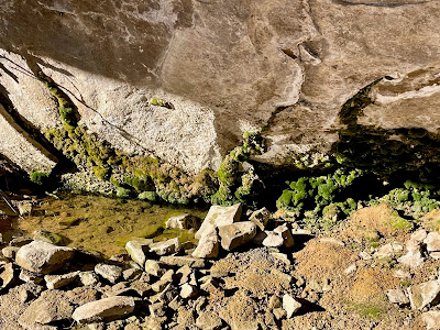
The ticketed group departed the parking lot and descended 135 stairs to a paved path along the edge of Soda Canyon. That took them to the first ladder and a climb of 32 feet upward. At the base of the ladder, was a “seep spring.” Seep springs are sources of water created by water draining through the sandstone. The water runs along ledges and pools in shallow places.
After climbing down to an access level, the tour continues by
climbing up the 32-foot ladder to the alcove level of the dwelling.
The seep stream supplies “running” water to the inhabitants
of the dwelling. That the stone of the mesa collects and holds
water is an amazing thing because drilling a well would be impossible
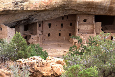
After climbing the ladder, the group walked through a narrow passageway to enter the alcove of the Balcony House. Most of the cliff dwellings were built closer to the base of the canyons but Balcony House was built 600 feet above the Soda Canyon floor. The alcove was 39 feet deep and 20 feet high. The complex is about 264 feet long and is believed to have had 38 rooms and 2 kivas. It is believed the Balcony House may have been used for educational purposes as well as cultural and ritual ceremonies. The rectangles in the walls are not windows but, in reality, are the actual doors the people entered through.
Access to the alcove and the rest of Balcony House
is through this narrow opening.
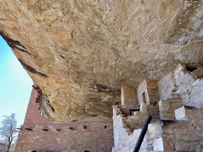
After going through the narrow passage, one enters the alcove.
This is the first view of what remains of the dwelling. Walls were
built from bricks fashioned with a mixture of sandstone and water.
The areas where the dwellings were built had been carved by the
wind and water under the capstone of the mesa. This photo
shows how the main walls were built to connect to
the naturally-formed ceiling.
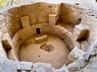
Leaving the alcove, the group climbed a short ladder and used steps chiseled in the rock to move to the area with the kivas, the courtyard. Kiva roofs were constructed of logs and adobe. They were level with the surrounding surface. The 3' x 3' hatchway in the center served as entrance and smokehole. A vent tunnel was also dug to the surface so a draft existed when a fire was burning.
In this photo, one can see the rooms and walls of the remains.
In the center of the photo is a ladder extending from a kiva.
Note that there is a vent on the wall that serves a basic function.
The cliff dwellings used the highest form of construction
developed to that point in time (1000 CE).
A kiva was a space used for rites and meetings. Among the
modern Pueblo peoples, “kiva” means a large room that is
circular and underground, and used for spiritual ceremonies.
Here is proof that Martha was there. As mentioned earlier,
what looks like a window was actually the doorway.
Inhabitants accessed a door by way of a ladder.
At the end of the tour, the group exited through a 12' long tunnel that was about 18" wide. At the end of the tunnel was a 17' ladder that led to a shelf. Once at that level, the group ascended stone steps and climbed another 17' ladder to the parking area.
Exiting Balcony House meant crawling through
this tunnel to get to another shelf or alcove of the cliff.
She made it! She was bit winded but glad to have made the tour.
This is an official NPS photo of Balcony House as viewed
from across Soda Canyon.
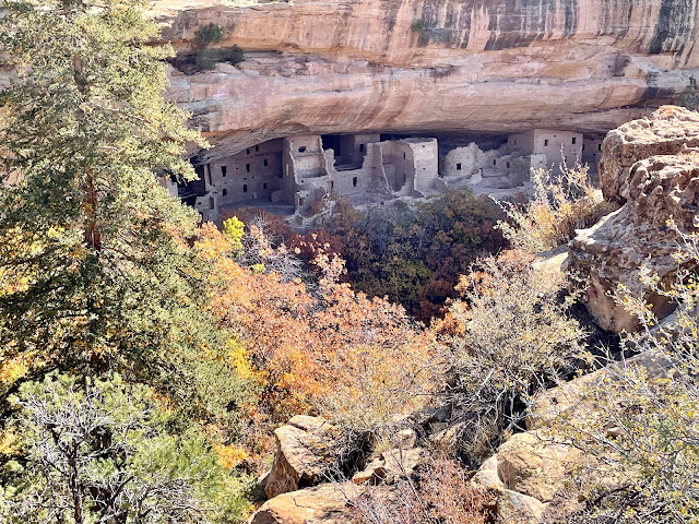
Evidence of the approach of Fall can be seen in this photo taken from across
the canyon. The Mesa Top Loop provides excellent viewing points
of several of the cliff dwellings.
After Martha met Byron back at the top (Balcony Parking Lot), we headed to the museum to watch a short film about the Ancestral Pueblo people who lived in this area for 850 to 1000 years. Before arriving in the area, the people had been hunter/gatherers. However, when they came to the mesas, they took up farming. By becoming farmers, they had to build dwellings so they could live in the location throughout the year. At first, they built pit houses on the cap of the mesa. It was later than they found safety in building their dwellings on the sides of the cliffs under standstone alcoves (shelves) that stuck out from the capstone. They raised corn and squash as well as turkeys. In addition, they still hunted for animals and gathered berries, etc.
After seeing the video, we had lunch at the parks grill. Byron had a grilled chicken sandwich that he said tasted better than any he’d had at Chick-fil-A.
Following lunch, we took the 6-mile drive around the top of the mesa. The 6-mile Mesa Top Loop takes visitors through 700 years of Ancestral Pueblo history. From remains of early pithouses and masonry villages to multi-storied cliff dwellings, archeological sites along this loop show how early Pueblo architecture evolved. Archeology and Pueblo oral histories shed light on what life may have been like for people who lived, worked, and raised families here for generations. There are 11 stops along the route. For us, it was hard to imagine that had all been done seven centuries ago and then abandoned by the ancestral people when they moved farther south.
We ended the drive around the loop at a viewing point for Cliff Palace, North America’s largest cliff dwelling with 150 rooms and 21 kivas. Cliff Palace stands as a grand testament to the engineering, architectural, and design achievements of these ancient Pueblo people.
A composite of pictorial information about the changes at Mesa Verde before
the inhabitants migrated south around 1300 CE.
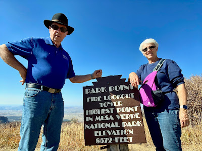
On our way out of the park, we stopped at Park Point which is as an elevation of 8,572 feet…highest point in the park. Before leaving, we went to the Visitor’s Center at the park entrance. Why? It was closed when we entered the park early in the morning.
Oddly, the fire tower is only operated during the summer months
which is the rainy season. The reason? To watch for lightning strikes.
We thought we could see Rock City from the northern view
of Park Point. For sure, we could see into other states.
This is a display of pottery and jewelry found on the mesas.
At the Visitor Center, we learned that the people had been using
tightly woven baskets before developing the ability to create pottery.
This was a wonderful park about people and their survival.
Our visit to Mesa Verde was the last on our list of national parks on this trip. Mesa Verde was wonderful and informative since it conserves the natural beauty of the region in addition to preserving some of the history of America’s indigenous people; people to whom we owe great respect.
We still have both Bush presidential libraries as well as the Johnson library and museum to visit before we return home. Stay tuned.
FYI, here’s the video shown at the museum.









No comments:
Post a Comment