This morning we got started about an hour earlier than normal. That means we were on the road by 9 AM. Since our dogs are still on Eastern time getting them to wait until 5:30 Mountain time to wake up is a feat. They stomachs are stuck on Eastern time and they’re used to eating their first meal of the day at 6:30 AM when at home. Martha has managed to get them to hold off nearly two hours.
The wind had died down by the time we were ready for bed from the night before. However, through the night it picked up and started rocking the motorhome on the particularly strong gusts. But, since the problem awning was tied in place we had no problems.
After leaving the Douglas KOA, we saw a sign that said Douglas was hometown to the Wyoming State Fair and the Jackalope. After doing a bit of research, Byron came up with a photo.
The fictitious and fabulous Jackalope.
Leaving Douglas, WY, our route took us through Casper, WY on Interstate 25. We stopped for fuel at the Flying J. Before getting out Byron commented that we had consumed more fuel than the previous drive of nearly the same distance. After he got through pumping he entered the information into his database. The result was that our mileage was cut to 5.81 mpg. Our cumulative average had been 10.35 until the last two days. As you can see, the headwind has taken a toll on the mileage.
From Casper we headed toward a town called Shoshoni on US 20. In the middle of the small town the road takes a 90-degree turn to the right to head north through the Wind River Reservation. We saw that we’d pass on the east side of the Boysen Reservoir and Boysen State Park, which is a large, man-made lake between Shoshoni and Thermopolis.
On one overview of the large lake we could see a train on the tracks about two miles away from us. It looked like a model train from our vantage point. We could also see ahead that there were some rocky cliffs. Little did we know that after passing the dam we’d head downward through a narrow canyon. The Big Horn River flows through the canyon. On the western side of the river the railroad hugs the rock cliffs. On the east side the three lane road winds it way downward. At one point we drove through three tunnels one after another.
Tunnels in the canyon walls of Wind River Canyon
After the tunnels came three detours were road construction was going on. However, this didn't detract from the amazing beauty of the place in addition to the man-made creation of rail and road bed so people, like us, could travel through such an interesting place.
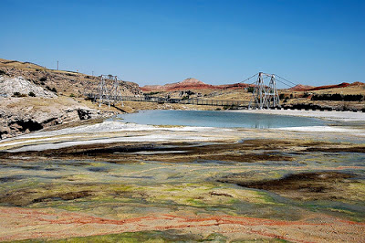
Immediately after leaving the canyon with it’s gray-colored walls, the rock ledges on the hills before us were a bright red-orange. The rock changed colors again as we came through Thermopolis, WY. Thermopolis is home to the world’s largest hot springs. The hot springs, like those in Yellowstone, have multicolored rock all around. The difference here is the fact that the pools of the springs is very large. They even have a suspension bridge built over one of the pools for pedestrian traffic.
Pools of the mineral hot springs in Themopolis.
Rainbow-colored terraces of the pools with suspension bridge.
In preparing for the trip, we had no idea we’d see the things we had just passed by. As a former friend of Byron’s used to say: “No amount of planning can make up for dumb luck.” That seems to be what we experienced.
But wait, we’re not there yet. We’re just a little over half way to Cody.
After coming into the town of Greybull we turned westward for the final leg to Cody. As it turned out, this 40-mile trek turned out to be quite interesting as well. First, we drove past the airport where the Museum of Aviation and Aerial Firefighting exists. Parked near the road is Fairchild Flying Boxcar with Canadian markings. Also on static display are nearly two dozen other aircraft including a Boeing Stratoliner and a Beech Super 18 which was used by the smoke jumpers.
Fairchild Flying Boxcar
Boeing Stratoliner (the military called it Stratotanker)
Beech Super 18
For an airplane buff, Byron thought this was an interesting find. What is even more interesting is that the town has a population of less than 2,000. Towns of this size don’t have such amenities in Kentucky.
Just before getting to Greybull and not long after leaving is where the wind seemed rather calm.
As we traveled on westward from Greybull it became obvious we were in the higher arid lands of Wyoming. The ground was much more rocky and sandy, sage brush grew all around and larger rock cliffs lined some of the way. It was also after leaving Greybull that we saw several antelope grazing along with cattle in the fields. By this point in the trip we had also crossed the original Oregon Trail in three places. It is also amazing how irrigation is dealt with in this area. Some fields are suitable for irrigating by running a large pipe around the perimeter. When necessary, water is emitted from the pipe to flow into the field. Since the field is at a slight angle and the rows plowed correctly, the water flows rather evenly over the field. Getting the water to the various distribution points is equally interesting. A system of manmade channels (aqueducts) have been constructed that meander through the area going from a high point of water impoundment. Just like gentle railroad grade, the water flows gently to the lowest point. The system calls for a cooperative effort among the farmer of the Conservation District to take only the water they need and pass the rest on to the downstream neighbors. What is common in this area is rare east of the Mississippi.
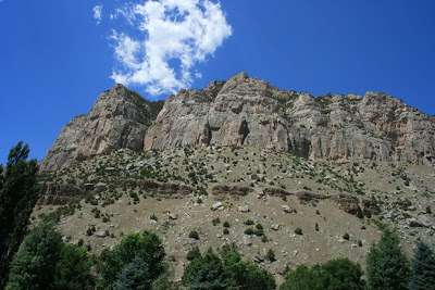
The large, rocky cliffs of the Absaroka mountains east of Cody, WY
As we came closer to Cody the snow-capped mountains of the chain in which the Grand Tetons exist could be easily seen in the distance. The views, though changing with each 100 miles of travel, remind us of the Woody Guthrie song: “This land is your land, this land is my land…”
After arriving at the Absaroka Bay RV Park, we went to dinner at Buffalo Bill’s Irma Hotel. We means the two of us and five other officers and spouses of the Diesel RV Club; the reason we are in Cody this time. Before closing this post, it wouldn't be complete without a picture of the most photographed site in Cody, the cherrywood bar and old cash register of the Irma Bar and Grill. By the way, the Irma Hotel is know as “the first hotel in the Rockies”.
Cherrywood bar and old cash register.
Thus far we’ve traveled just about 2,000 miles. It has been enjoyable and amazing. The only thing better than sharing it via the blog would be to have you all ride along with us in person. The one bad thing is that it requires a lot of sitting but it is worth it when we come upon some beautiful and/or interesting sites. We’re seeing things that can’t be seen from the air or from the side of a railroad car on a passenger train. We’re seeing things out the panoramic view of the front window of our Airstream Land Yacht XC.
This land is your land…


No comments:
Post a Comment