Saturday, September 30, 2023

Day 23 - 9/27 - Up the Columbia Gorge to Hood River and Back

Today was the second day for seeing some sights around the Portland area. We took a tour through Wildwood Adventures up the Columbia River Gorge to Hood River and returned via parallel roads to Portland. Today was also our first experience with Uber rides.

We met the first Uber driver at the campground. He took us to the downtown area where we’d meet the van for the tour. Another person was also there waiting for the same van. He was originally from India but was working for Aramco in Saudia Arabia. He was in the USA for a conference.

The description of the tour stated there would be several waterfalls along the scenic drive. Our turnaround point would be Hood River (below Mt. Hood), a small town that caters to tourists rather well. The return would be through the fruit-growing region of Oregon. The trip was a full-day engagement dean 7:30 AM ti 4:30 PM. Along the way, we learned a lot about the region.

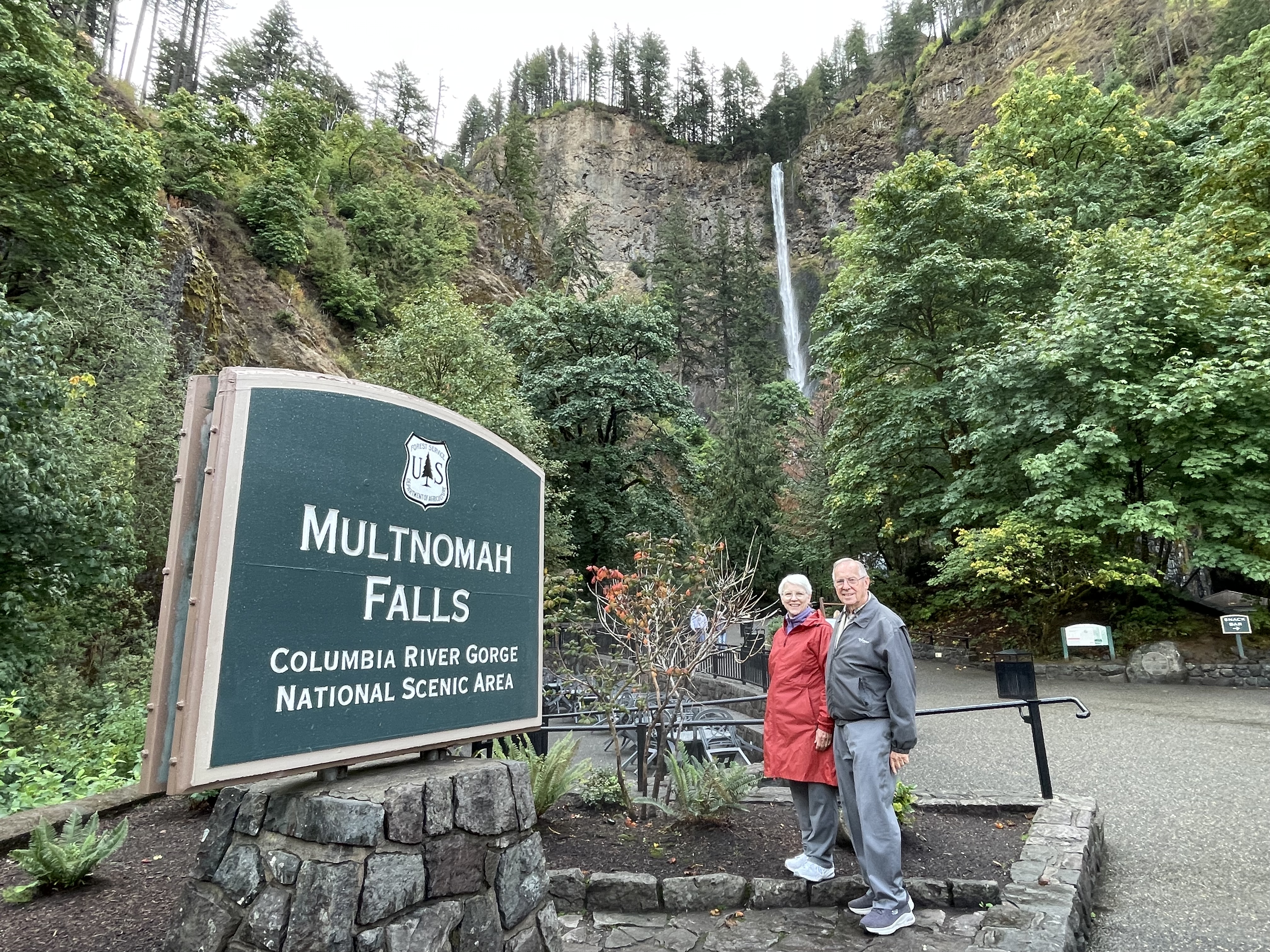
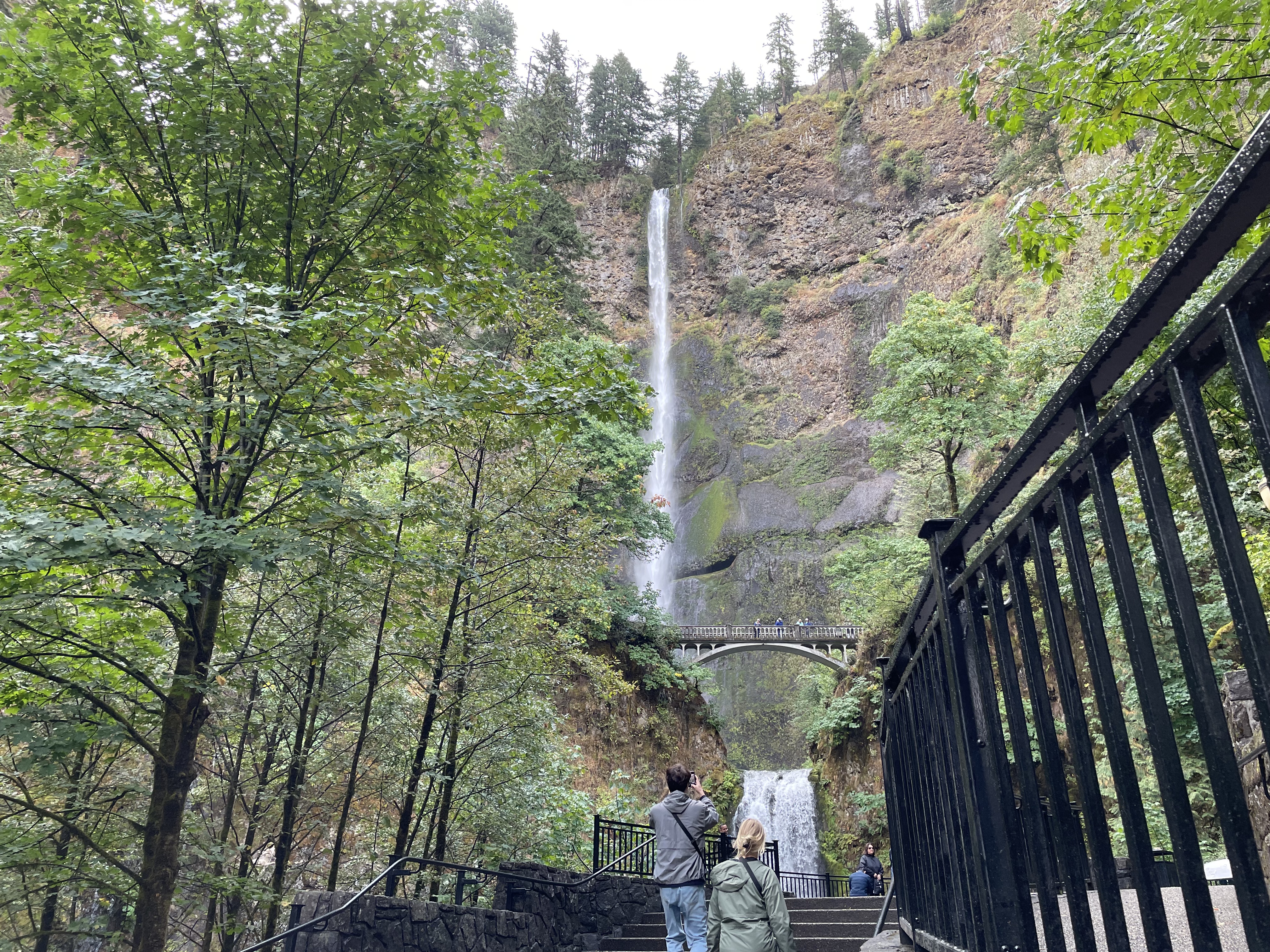
The tour began with a stop at Multnomah Falls, the third highest waterfall in the 50 states. From Multnomah, we headed to Crown Vista Point House. This structure was the first purpose-built rest stop in the country. The building sits atop a point 733 feet above the Columbia River. It was built between 1916-1918 as a memorial to Oregon pioneers. It served as a comfort station for those traveling the Columbia River Highway. It also served as an observatory. The Vista House marks the beginning of a 75-mile scenic highway that was built in 1913. According to our driver, it was the first stretch of paved roadway planned as a scenic drive.

Multnomah Falls
Multnomah Falls is a popular stopping point for tours and travelers.
The falls is 620 high. There is a pool that it drops to that is
70 above the base of the falls.

Bridge above the pool
A paved path leads to the bridge that spans the gap above the
lower pool of the falls.

The Crown Vista Point House
The Vista House was designed by architect Edgar Lazarus 
in the style of German Art Nouveau. The octagonal building
stands 55 feet high with tall, opalized glass windows
offering 360-degree views of the gorge. The building’s
peachy-hued walls are pink limestone. It is on
the National Register of Historic Places.

Before arriving at Hood River for lunch, we passed quite a few waterfalls. There are so many that it would take quite a while to find and explore all 100 waterfalls in the Columbia River Gorge. Each of them, of course, is unique in some way, even Horst Tail Twist Falls.

As mentioned, we had a lunch stop in Hood River, Oregon. Before being let out we were told that a favorite of people in the area was the marionberry. That being the case, we had to have a piece of marionberry pie. Fortunately, Bette’s Place had that as a menu item and had enough pieces for us. Marionberries are a cross between a raspberry and a blackberry.

From Hood River, we traveled through the Hood River Valley where pear, apple, peache, and berry orchards are plentiful as well as numerous wineries. Hood River Valley is bounded by the Columbia River to the north, Mount Hood to the south, the Cascade Range crest to the west and a ridge system to the east which contains Hood River Mountain and Snyder Canyon.

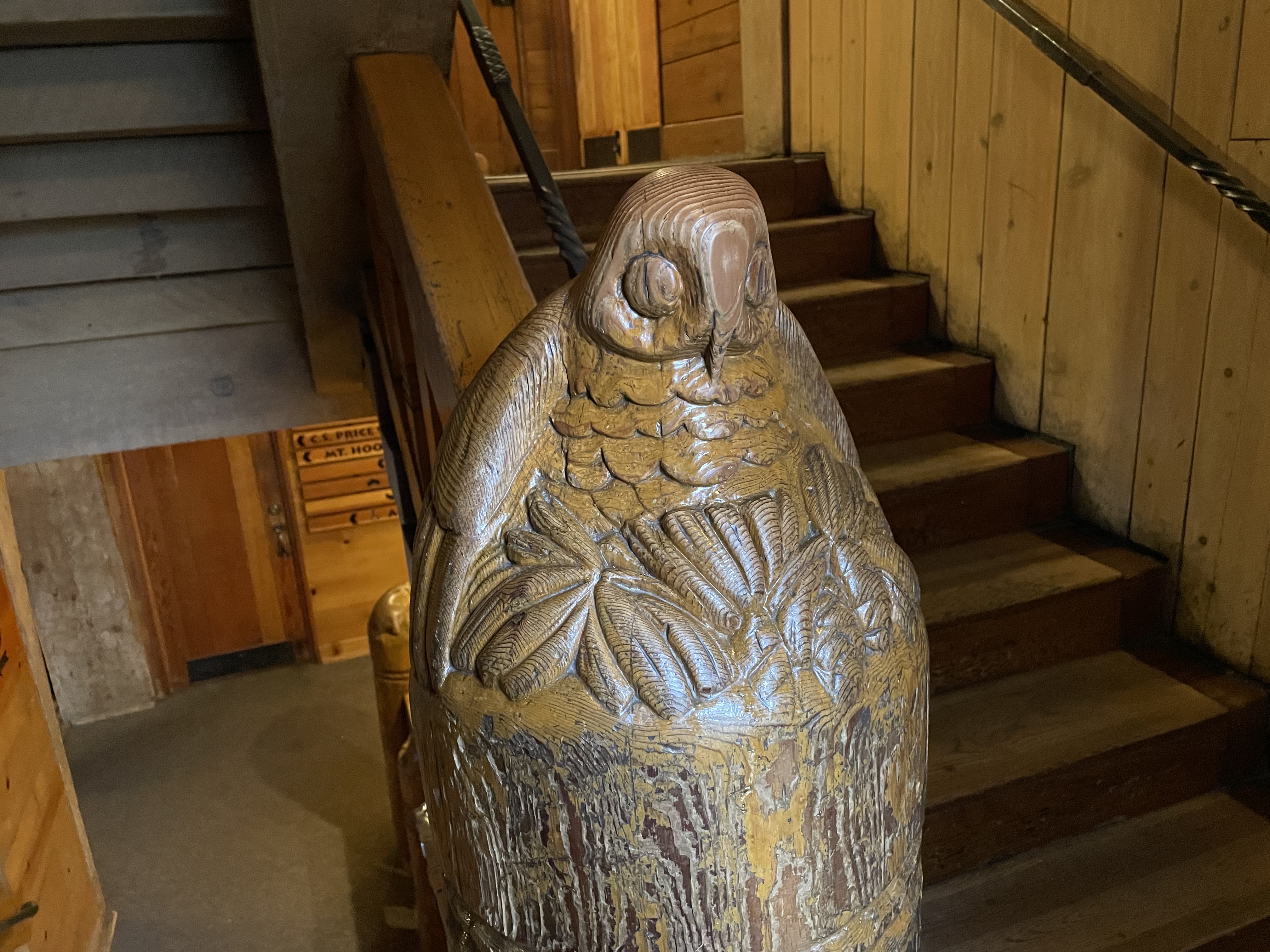
Our final stop before returning to Portland was the Timberline Lodge. The lodge is at 6000-foot elevation on the south side of Mt. Hood. Timberline Lodge  was about 60 miles east of Portland. Constructed from 1936 to 1938 by the Works Progress Administration, it was built and furnished by local artisans during the Great Depression. Timberline Lodge was dedicated in 1937 by President Franklin D. Roosevelt.

Timberline Lodge is a mountain lodge on the south side of Mount Hood in Clackamas County, Oregon, about 60 miles (97 km) east of Portland. Constructed from 1936 to 1938 by the Works Progress Administration, it was built and furnished by local artisans during the Great Depression. Timberline Lodge was dedicated September 28, 1937, by President Franklin D. Roosevelt. By the way, the Mt. Hood summit peaks at 11,245 feet. The mountain peak was not in view due to the rain and fog.

carved newell post
Timberlin Lodge was built using local resources by employees
of the Works Project Administration. All of the Newell posts
in the lodge were carved by WPA craftsmen. They are of 
local wildlife in the area; bears, cougars, owls, eagles, etc.

Once back at Portland, our second Uber driver met us near the Studio Building. We enjoyed the conversation on the way back to the campground. The we and the driver laughed a lot as he spoke about growing up with adopted parents who were Norwegian. He was born of Black parents from Barbados who returned when he was five years-of-age and put up for adoption.

Studio Building
The Study Building has an interesting history. It was built in 1927
by the Ellison-White Conservatory of Music. The building originally had
128 studios for actors and musicians. The exterior displays
busts of famous composers. The street level
is now occupied by the restaurant Pastini.


Day 22 - 9/26 - In the Portland Area

We made it to Portland in time for the rain. Imagine that! Did it slow us down? No.

On the agenda was a visit to the Japanese Garden, International Rose Test Garden, and the Oregon Museum of Science and Industry. The Japanese Garden is closed for maintenance on Tuesdays so we immediately went next door to see the roses. They are both in Washington Park which is on a hill in Portland that overlooks the Willamette River. Though it was cloudy all day with rain on and off, the temperature was not a problem for us.

Some plants (the test ones) at the test garden are considered as specimens for testing and judging. Other plants are planted in quantity. That is, the award-winning roses that span a history of nearly 50 years of hybridization. They also have a wide variety of types. The most abundant is Hybrid Tea. Other types include English, Grandiflora, Floribunda, Knockout, Miniature, Climbing, and Tree roses. By the way, tree roses are based on a bush type grafted to a slow-growing tree trunk. The beds are well organized and well maintained. There’s even a listing of the inventory and a map that designates where each variety is grown. Everything is labeled, too. In spite of all this detail, it is still easy to get confused as to which rose you liked best and where it was located.

Martha & Byron at Intl Rose Test Garden
Our first stop, the International Rose Test Garden in Washington Park.
Though late in the year for roses, this place is still beautiful
with quite a spectacle of roses.

Composite of six roses
How about a composite of a few rose photos?

rows of roses
Rows and rows of roses. Some are much more fragrant than other.

Having completed our jaunt through the roses, we headed down the hill to the Willamette River and the Oregon Museum of Science and Industry. At the museum we encountered many children. What was it? A free day? We never found out. But, once inside and after walking about we did see that nearly every exhibit was of the “hand-on” variety. That means it was designed with curious kids in mind.

Since we’re not kids anymore, we decided to pay the extra fee and take the tour of the submarine. The tour, unlike the WW II U-boat in Chicago, this was a guided tour that was about 45 minutes in length. In order to take the tour, we had to prove we could climb through a doorway since we would encounter two on the tour in the sub. We passed. For us, the tour of the SS-581 was the highlight of the museum.

to USS Blueback
We are preparing to board the USS Blueback for a tour of the submarine.

Nav Room - condition red
This photo was taken in the control and navigation room. We were
shown what it was like to be under “red light” conditions. When the
crew is underwater (away from daylight) for days at a time, the red
lighting serves two purposes. First, it helps the crew to know
the difference between day and night. Second, red is uses
at night because its light waves do not travel as far as white light
which can be reflected up the periscopes, etc. This makes the submarine
harder to see at night from the sea’s surface.

Torpedo room
The sub can carry 18 torpedos. Six are stored in the tubes and
another dozen are held on storage racks. We also learned
a few things about the varieties of torpedoes.

engineering controls
This photo of of one of the control panels for monitoring the HVAC
system, the diesel engines, and the generators. Diesel-powered
subs can generate and store enough electricity (during a day on the surface)
to operate up to 4 and one-half days submerged.

the screw (propeller)
Commonly referred to as the screw, this was the last propeller
used on the Blueback. It now stands at a memorial
to all submarines lost in service of the USA.

An additional fact or two — the Blueback was a class of submarine developed after WW II. It was placed into service in 1959 and decommissioned in 1990. The class was designed to be a fast-attack sub. This means that its cruising speed underwater was as great as the cruising speed on the surface. That was something no WW II-era sub could do. It was also smaller than the subs of the previous era. It hosted a crew of eight officers and 69 enlisted crew members. No torpedo was ever fired during that era of tension with the USSR. To be qualified to serve, each crew member had to pass a test on every facet of operation of the sub and had to be able to demonstrate the use of the various controls. The reward was a higher grade of pay and a pin that accompanied the designation.

Friday, September 29, 2023

Day 21 - 9/25 - From Port Angeles to Portland

This entry will be brief. The main reason is that this was a travel day. A secondary reason is that the photos are beginning to look very much the same; clouds, evergreen trees, water, and roadway. Well, the roadway may look different because much of it was very curvy today.

The first part of our drive on US 101 East was about 130 miles. The many turns and hills meant seldom reaching a speed of 50 MPH. In addition, we went through four portions where some type of construction brought the highway to one lane roadway. Of course, it was raining but that didn’t keep anyone from working. The proper attire for working outside is a rain suit.

In checking prices for fuel (they greatly vary out here), we did stop for fuel near Olympia. By the time we arrived at Roamers Rest, it was time for supper (some people call it dinner) and time to rest up for the next day.

Olympic National Park map
Our travel route was from west of Port Angeles (near Elwha),
around the east side of the park on US 101, and down
to Olympia, Washington where we merged on to
I-5 to continue on to Portland, Oregon.

Rooamers Rest
This was our destination campground, Roamers Rest RV Park.
It is in one of the suburban areas south of downtown
Portland in a community called Tualatin. The campground
was a former public park space.


Thursday, September 28, 2023

Day 20 - 9/24 - Into Olympic National Park - part two

Today was our second day to go places in Olympic National Park. We headed west from our campground to Rialto Beach which sits on the Pacific Coast. We got an early start in hopes of getting ahead of the rain.

Rialto Beach is decorated with some serious driftwood called “beach logs.” Fallen trees that make their way down the cascading rivers and creeks are deposited on the beach if they don’t fully make it to the ocean. The winds and other winter conditions provide for the conditions and force for moving them. Initially, they get to the ocean where the tides force them back to the beach edge. They can sometimes remain in place for years along the edge until other storms carry them out to sea where they may later be pushed back on the beach.

Rialto Beach and logs
Welcome to Rialto Beach and beach log heaven.

At Rialto Beach
Byron, dressed as the man in black, and Martha standing
at the root cluster that is still attached to the trunk of a tree.
Interestingly, these trees lack tap roots since they
existed in a rainforest.

The beach is made up of smooth rocks of all shapes and sizes. It is as though they fell right out of one of those rock tumbling machines. There was no sand. The beach was also littered with various types of sea weed. After a short walk among the various pieces of beach logs, we headed to Hoh Rain Forrest.

We have seen many moss covered trees over the last two days as well as abundant ferns of different species. If you look carefully in one of the photos (below), you will see the “moss monkey.” Vegetation of all kinds is abundant in this rainforest habitat.

moss monkey
Moss drapes over many of the limbs of the trees. Do you see
the “moss monkey” in the photo?

mossy tree fork
It appears that many years ago this forked-tree hay have really
been two trees that merged near the base. If it is green, it is
moss. If it is yellow, it is lichen – or so we have been told.

uprooted tree
We took a 1.2 mile hike at the Hot Rainforest along the Spruce Trail 
and came upon an old Douglas Fir which
had toppled over. The underside of the
tree made for an interesting photo opportunity. 

Byron and Martha at Hook
As you can tell in this photo, some signs of fall are beginning
to appear in the lower elevations where deciduous trees
and bushes exist.

This morning, we streamed the worship service from our home church in Louisville as we have one previous Sundays. But, out here in nature, we are able to see the signs of God’s handiwork across millions of years of development. It is amazing.

Washington State has not disappointed.We head south on Monday. As far as Martha is concerned, the cake has been baked and anything we experience for the rest of the trip is just icing on the cake. As for Byron, he’s looking forward to more cake and icing, too. He’s waiting to see Martha’s reaction to the sights around San Franscisco. There’s more wonder from the wandering to come.


Tuesday, September 26, 2023

Day 19 - 9/23 - Into Olympic National Park - part one

If we could have ordered good weather, we would have done it for today. Yesterday, when returning to Port Angeles from Victoria, it was too smoky to see Mount Olympus in the middle of Olympic National Park. (A wildfire broke out several days earlier in the park. Since there is no danger to infrastructure the decision has been to let it be put out by the weather.) Today? Damp, rainy weather decided to move in bringing with it a low ceiling and limited visibility. It was not a sunny day. However, it was ideal for helping to extinguish a fire.

at the park's sign
It was cloudy and damp feeling when this photo was taken.
It was yet to rain. That came later.

Olympic National Park is similar to Mount Rainier NP in that you can drive around it and into it; you just can’t drive through it. Like Theodore Roosevelt NP, there are no connecting roads to link one major visitor area to another. Like Mt. Rainier, one must drive to different entrances and explore inwardly from the perimeter. By the way, it must be about 160 miles around the edge. US 101 splits at the lower south-eastern part of the park, near Olympia, and wraps around the park, coming back together near Port Angeles.

We started our visit at the Olympic NP at the Visitor Center in Port Angeles. It is located at the north-central part of the park. We entered the center in search of what a ranger would recommend for our two days at Olympic. In the midst of the discussion, we learned the park ranger was also from Louisville, our home base. In fact, he was from Jeffersontown (what we call J-town).

inside the visitor center
The verbiage of this display provides a good overview of the
varied treasures to be found here. Glacier-capped mountains (when visible),
alpine meadows, spectacular coastline, ancient forests, fish and
wildlife, sparkling clear streams and lakes, native and pioneer history,
exceptionally clean air, biological diversity, and wilderness solitude.
There’s only one national park that offers more — Yellowstone.

Our first stop was Hurricane Ridge which is a drive up to an elevation of 5700 feet. On a clear day, we know that the view would be beautiful. Today, however, Mr. Rain decided we did not need to see the mountains or the valleys more than 1/2 mile in any direction! We drove on the curvy road anyway just to get the experience. From Hurricane Ridge, we headed down and west to Lake Crescent Lodge.

interpretive sign
This explains what we should have seen…
view from the edge with clouds to interfere
…when we actually could only see this.

steep slopes and short tunnels
We encountered steep slopes and three, short tunnels in
our drive to an elevation one-mile high. Some slopes
are too sleep for trees to take root. Others aren’t so steep
yet at an angle that would make hiking difficult.

On the way down we saw a wrecker and two NP cars making an attempt to drag something back up to the roadway. We didn’t see what it was because the bank was too steep to see. Obviously, if it was a car, the driver found that taking the shortcut from one curve to another was not wise.

Lake Crescent is a beautiful lake where the Olympic mountains run right down into the lake. All around the lake, there are steep slopes. At its deepest point, Lake Crescent is 620 feet deep. At the lake, we set off on a 1.6-mile hike to Marymere Falls. It was still raining, but when you’re only in the area for a few days, you embrace the rain and keep going. Quite a few others felt the same way because the trail was busier than we expected.

beside Crescent Lake
At Crescent Lake on a day that was damp, cold, and cloudy.

mossy tree
Moss-covered large trees in an ancient forest area where
the 350-foot high trees provide little sunlight to reach the ground.

huge trees
Many of the trees on the hike to Marymere Falls are huge at
the base and reach up hundreds of feet toward the sky.

huge ferns
The ideal environment for huge ferns exists.

Our final stop of the day was a drive to the Sol-Duc Hot Springs area of the park. Along the way, we stopped at the Salmon Cascades area of the river. Sadly, no salmon were making the trek upstream.

Sol Duc Hot Springs
The hot springs at Sol-Duc are open to those willing to give them
a try. Just be sure to have a towel and robe when returning
to change back into street clothing.

In spite of the weather, Olympic National Park is an amazing place. Though similar to Rainier, it is also quite different in several ways. They both are fascinating parks for which we should all be thankful.

Day 18 - 9/22 - To Victoria and Back

This was the day we knocked off one of the items on Martha’s bucket list; a visit to Butcharest Gardens on near Victoria, British Columbia. Our trip was made easy by taking the M.V. Coho, a year-round passenger and vehicle ferry that goes between Port Angeles on the scenic Olympic Peninsula to Victoria on Vancouver Island.

MV Coho
Byron grabbed this photo of the Coho in front of The Empress
hotel on the Inner Harbor of Victoria. The ferry loads vehicles
from the aft in Port Angeles and from the side in Victoria.

We had our tickets and passports in hand when we arrived at the ferry terminal for the 90-minute cruise. We elected to not take our car but to be pedestrian passengers and utilize a shuttle to get to Butchart. Though the day started off with a bit of smoke from a wildfire, the sun was out, the temperature ideal, and no rain was in sight. On the trip

The Empress Hotel
The Inner Harbor at Victoria is larger than expected. As we
were entering, smaller boats were coming and going
as were sea planes operated by Harbor Air.

Harbor Air terminal
Harbor Air’s terminal was not far from where we docked.
For us, it was odd to see a de Havilland Twin Otter on pontoons
taxi to the pier beside the ferry.

Legislative Assembly
Before boarding the shuttle bus, we walked around the harbor
area especially since our attention was drawn by this
legislative assembly building and the totem pole (to the right).

Bus stop at The Empress
Even waiting on the bus one can view the flower garden in
front of The Empress Hotel.

Though we didn’t plan it, the shuttle turned out to be double-deck bus operated by Gray Line. Yes, we were on a tour bus with wonderful narration provided by the driver. So, yes, we got to see highlights of Victoria and learn even more about the beautiful area.

Public Chinese School
This is Victoria's first Public Chinese School. It still
serves Victoria by offering classes to those
wanting to learn Chinese.

Entrance to Butchart Gardens
Here we are at the Entrance to The Butchart Gardens.
What was ahead was a visual treat!

manicured lawn and flowers
Even the grassy areas are manicured nicely.

sunken garden
The Sunken Garden was the first area developed with flower
and trees. This area was the former limestone quarry.

sunken fountain
How would you like this fountain for a water feature on your property?
All that is required is money and space; simple.

Japanese Garden
The Japanese Garden features a star-shaped pond with 
closely trimmed shrubbery serving as a border.

flowers in full bloom
These were only a few of the photos taken. But, as you can see,
every thing was lovely, for sure. The mums? They were
yet to explode into their full color.

Butchart Gardens is a landscape garden created by Jennie and Robert Butchart after mining the limestone in the area to produce cement. This was done in the first quarter of the 1900s. The Sunken Garden was created in the former limestone quarry by Jennie and Robert. There is also a rose garden with 2500 rose bushes and over 250 species, all of which were still in bloom. Over the years, under the direction of a grandson and now great-granddaughter, a carousel, dragon fountain, sturgeon fountain, Japanese garden and Italian garden have been added. The garden covers about 55 acres of the original property of 200 acres.

The Gardens receive over a million visitors each year. It is a National Historic Site in Canada. Jennie Butchart, whose dream The Gardens have become, died in 1950. Her husband, Robert, died seven years earlier in 1943. The site is still operated and under the control of the founding family. 

It was truly amazing and beautiful to visit!

Monday, September 25, 2023

Day 17 - 9/21 - From Gig Harbor to Port Angeles

Time to move from our location, again. This travel day took us from Gig Harbor, near the Seattle-Tacoma metropolitan area, to Port Angeles in a relatively remote part of Washington adjacent to Olympic National Park. If you don’t know where that is, it is in the northwestern corner and still near Puget Sound. It is closer to the Pacific Ocean than Gig Harbor. Our reason for getting here was twofold. The first was to make it to Victoria on Vancouver Island in British Columbia. The second was to spend some time exploring Olympic National Park.

Since it was a travel day, what we encountered was much like other travel days in the Pacific Northwest: Up and down changes in elevation of a couple hundred feet, lots of pine and spruce trees, and mountains. Byron estimated that over the 100-mile drive we had to go up and down more than two dozen times. Can you say “roller coaster?” There were also frequent turns like that of a coaster.

Our reservation was for Elwha Dam RV Resort, eight miles west of Port Angeles and a short distance from US 101. We arrived in the early part of the afternoon with enough time to go to the local Safeway for groceries and sticker shock. Even in Port Angeles, the cost of living is much higher than what we’ve been accustomed in Central Florida or Southern Indiana.

After returning from Safeway, we walked around the campground to learn more about Elwha Dam and the immediate area. The dam was on the river to facilitate a hydroelectric generating station. There was no salmon ladder built for the dam and the salmon stopped returning to the river. After two decades of study and deliberations, the decision was made to remove the dam and another since other sources of electricity were available. The 2011 decision was part of a National Park Service plan to restore the altered ecosystem of the area. About a year later, salmon started returning to the river and fishing soon followed. The ecology of the area was returning to what it had been a century earlier. Today, the Elwha River once again flows freely from its headwaters in the Olympic Mountains to the Strait of Juan de Fuca before going on to the Pacific Ocean.

Ridge over Elwha Dam RV Resort
The ridge above Elwha Dam RV Resort reveals a fact about which
we had been curious. It was as though hardy trees had survived
a forest fire. The truth revealed to us was that the slopes are so
steep that only a few trees can grow along the peak of the ridge.

Martha on the Elwha walk
This area of Washington (the north side of the Olympic peninsula)
does’t receive much rain. However, it is low enough in elevation
that the air is damp. On our walk between the RV resort and
the former dam site we came upon this lowland where moss
is growing on fallen trees and there is an abundance of sword ferns.
The 200-foot tall evergreens shade the ground below it providing
a dark and damp environment for such growth.


Saturday, September 23, 2023

Day 16 - 9/20 - Mt. Rainier and the National Park

The weather forecast for today was less than promising. Since we’re not able to order the weather we want when we want it, we just have to go with the flow. Such was the situation for today’s visit to Mount Rainier. While we have always been aware of Mt. Rainier, we weren’t totally prepared for what we were to experience whether cool or warm, wet or dry, sunny or cloudy. Ascending to 14,410 feet above sea level, Mount Rainier stands tall in the Washington landscape. An active volcano, it is the most glaciated peak in the contiguous U.S.A. and is the beginning point for five rivers of significance. 

Gig Harbor, where we have spent the night while in the Seattle-Tacoma area, is several miles north and west of the National Park. We started out a little later than normal because it was rainy and cloudy. Getting to our intended destination took nearly two hours. We wanted to get to Paradise, the area on the south-central edge of the Park. To get there we entered through Nisqually which is on the southwest corner. (MoRa, as the stickers denote, has four entry points.) It seemed to get worse as the day went on.

Mount Rainier National Park Map
Entrances into Mount Rainier National Park are near the
corners of the park boundary. We entered from the
southwest at Nisqually.

Martha had done a little preparation for our visit and knew that our first stop would be Longmire and a visit to the small museum there. By small, we’re talking a cabin that was 16' x 24' or so. It was the first ranger office at the Park. Longmire serves as a small and permanent community for employees and also has other amenities for park visitors (tourists).

Longmire service station
Need fuel? Stop in at the Longmire service station. It is well-preserved
though no longer operational.

Longmire Museum
The original headquarters building at Longmire has served
as a small museum for Mount Rainier.

From Longmire, we traveled toward Paradise and the Henry Jackson Visitor Center. We had packed a picnic lunch, but at the 5,400-foot elevation and cold, misting rain, we opted to picnic in the car! As we looped around to exit the picnic area, Martha spotted three deer grazing next to the roadway. So as not to scare them away, she inched the car closer to them so Byron could get a picture. 

doe and her fawns
A doe and two fawns were standing near the roadway. The spots
on the bodies of the fawns were nearly faded. Two types
of deer inhabit the Park; black-tailed and mule deer.

We arrived at the Visitor Center in Paradise. Though we had seen few cars on the road, we saw a nearly full parking lot. It was obvious that “this was the place” at which to be even on a cold, rainy day at 45° F. We always like to see the introductory videos so we watched the short, 20-minute film of the Park. It was quite informative and pointed out that Mt. Rainier, though the fifth National Park, was the first park that had been created with a careful plan in mind for use and maintenance. For instance, the structures that were developed became the standard for implementation in many of the other parks of the NPS. For sure, Paradise has its name for good reason because it offers the best of all there is to experience at Mount Rainier.

At Paradise inside Mt. Rainier
On this trip, we’re getting photos of every national park sign
and every presidential library we visit.

Byron among the ferns
Byron was impressed at the multitude of perennial ferns that
grow wild and healthy in the Pacific Northwest.

the color of Ranier
Along one section of road, we captured some of the color
yet to be seen in Rainier even though it was September.

The relief map on display in the Jackson Visitor Center provides
and excellent overview of the terrain as well as the large
glaciers at Mt. Rainier.

Rainier interpretive poster
Yep, a lot of snow falls at Paradise during the winter months. The short
growing season produces a rare amount of beauty that is easily reached.

As we were walking away from the Henry Jackson Memorial Visitor Center, we remarked to each other that we now have a good reason to return. The many glaciers, rivers, trails, variety of scenery, and weather developed here are truly amazing. Just think, we were only about one-third of the elevation of Rainier which is above 14,000 feet. More to see? Yes, indeed! Subalpine wildflower meadows ring the icy volcano while ancient forests surround Mount Rainier’s lower slopes. Wildlife abounds in the park’s ecosystems. A lifetime of discovery awaits and we were here only a few hours. The bucket list has not been shortened.

On the return to the RV resort in Gig Harbor, we stopped in Elbe for some huckleberry ice cream. Huckleberry flavoring is popular in the northern half of the Rocky Mountains.

Shay locomotive at Elbe
This Shay-type locomotive sits on display next to Elbe’s train station
for Mount Rainier Railroad. Shays were frequently used in
mountainous logging areas. Designed for power and maneuverability,
they were not used in typical freight or passenger service.