Another travel day. This involves getting up in time to hit the road at 9 AM if possible. We have miles to go before we sleep. The only promises to keep are those of seeing places and doing things that remain on the bucket list.
We left Aberdeen, South Dakota with a 300-mile trip ahead of us. We headed northward on State Highway 281 toward North Dakota. This would be our first time to be in that state. The further north we travel, the less populated the area becomes. Highway 281 is a two-lane road. Other than two small towns with speed limits of 35, we were able to travel at our normal speed of about 62 mph.
Corn and soybean fields were our traveling companions again today. Like some much of the wide-open prairie of the Great Plains, one can drive for miles without seeing a house. Then we see someone’s farm or ranch and grain silos way off the road, surrounded by fields of crops or cattle. Then, just as quickly one sees them, they fade into the passing horizon before seeing another, similar setting.
Martha wrote the following in a Facebook post. “I am by no means an extrovert. I enjoy my solitude and quiet, but I’m not sure I could survive here. I do enjoy face-to-face interaction with people daily.” Byron also enjoys watching people too much to enjoy being alone on the prairie.
We intersected with I-94 at Jamestown, North Dakota and turned west toward Dickinson, North Dakota. As we traveled I-94, we traded fields of soybeans for acres and acres of sunflowers interspersed with fields of corn and wheat, all in various stages awaiting a sure harvest sometime later this fall.
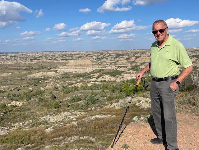
We crossed into the Mountain Time Zone about 30 miles east of Dickinson. We arrived at North Park Campground a few minutes after 1 PM and still had a good amount of daylight left. So, we headed out for the Painted Canyon Visitor Center at Theodore Roosevelt National Park. This was to be our first glimpse of the Park. We’ll return to see the North and South Units of the Park and also visit the small town of Medora.


No comments:
Post a Comment