Sunday, June 16, 2013

Western Swing 2013 - 24 - Seven Falls and Pikes Peak

Saturday — Martha doesn’t have to work, the sky is clear blue, and the temperature is great. The wind has dissipated much of the smoke from the Black Forest Fire as it has come under control. It’s a good day for getting out to see a couple of the attractions around Colorado Springs. Since we have Redford, Julie Ann, and Tiger traveling with us, we can’t be gone from the motorhome all day so we’ll handle our visits in two trips.

Our first trip was to Seven Falls. Martha came across this adventure from reading a brochure available locally. Seven Falls is near one of the public parks operated by the City of Colorado Springs. It, like many of the natural sights in the area including Garden of the Gods, is a privately owned, commercially developed attraction. Unlike Garden of the Gods, there is a charge for parking and exploring the feature. Seven Falls was developed as a feature for tourists in the late 19th century before the US had a park system.


Seven Falls is a series of seven cascading waterfalls of Cheyenne Creek in
Cheyenne Canyon. It is part of the fall line of the
Colorado Front Range. The sum of the height of the
seven falls is 181 feet. This photo shows a pool and three falls
as seen from the half-way point on the stairs that
ascend from the visitor center.

On the way down the first flight of steps Byron took time to capture
Martha’s descent. There are a total of 224 steps on the staircase
from the base to the peak. Trust us, it’s easier on your heart,
lungs, and leg muscles to take them 10 or 12 steps
at a time with brief pauses to look around. From the 
vantage point in this photo the canyon floor is in the upper right
corner of the photograph about 150 feet down.

About three quarters of the way to the top Byron noticed some 10-inch pipes and wondered if water was pumped to the head of the falls. Sure enough, the water is pumped from the pool from a man-made pool at the base to the top because, at this time of year, the creek feeding the falls doesn’t flow fast enough to provide any significant flow. The melt-off of snow has occurred. The owners have also provided lighting at different levels for viewing in the evening.

Once at the peak of the falls, visitors may take a one-mile hike around to another viewing point (Eagles Nest) where an elevator has been installed by cutting through the rock. We, however, chose to go up and down the steps at the falls and then walk to the elevator ride to Eagles Nest. From this viewing point it is possible to get take a photo of the full view of the falls. A larger photo showing all the falls on Wikipedia is available here.

After returning to the KOA for lunch and caring for the pets, we struck out for Pikes Peak. In typical fashion for this time of year, clouds were beginning to build on the edge of the mountains where they build pressure and then force themselves on eastward.

There are three ways up Pikes Peak. Hike, drive, or take the Manitou Springs & Pikes Peak Railway, a cog train, to the top. Either way, the trip involves several miles winding back and forth through the forests, bolder fields, and area above the permafrost. The drive up is a little less than 15 miles. The difference between driving and taking the train is roughly six miles. The reason for the difference, if you can’t figure it out, is that an automobile can’t handle the steep grade the way a cog train can. Be aware, however, that there’s a toll both along the way and that a part of the roadway isn’t paved. (Go here for some panoramic photos taken along the highway as well as additional information about the trip by automobile.)


Hiking is done by taking the Barr Trail. Barr Trail offers a spectacular route up the Peak. It is also the course for the Pikes Peak Ascent and Marathon races each summer, which attract thousands of runners from all over the world. The trail offers the greatest base-to-base summit climb in Colorado, with an altitude gain of over 7,800 feet in 12-plus miles. It is the most difficult regional trail because of the elevation gain and the distance. Take our advice, the M&PP is the route to take unless you’re a young, enthusiastic hiker or extremely well-prepared marathoner.

This sign at the terminal let’s travelers know what
to expect at the 14,100-foot summit. We brought our
jackets but didn’t think about oxygen. Not to
worry, 50-breath bottles are available in
the gift shop. If unused, the bottles can
be returned for a full refund. Nice.

We rode in the first car of the consist. Note the arrangement of the teeth
and rails for the cog system. The average degree of angle is 14 with the
maximum being about 25. That’s a steep incline.
Seating is assigned. Seating is in a 2 x 3 arrangement with rows
facing each other. Fortunately for us, the partner across
from Martha was about 5' 2" so they didn’t
bang knees. There was no one sitting opposite
Byron so he had no problem.

Photos do not adequately show how steep the angles are nor the subtlety of all the vegetation and changes in the surface features. The trees change while changing elevations, of course. The rocks and formations change in size and orientation, too. At some points the formations are nearly vertical like in the Garden of the Gods. The boulders are tremendous in size and one wonders how they stay in place. There are creeks with water streaming from the remaining snow or from the springs that dot the mountainsides.

OK, we have to do this. Byron took Martha’s photo and
Martha took Byron’s. They had their “world famous doughnuts”
for sale. We have yet to figure that out because they’re
just cake doughnuts with no icing or other decoration.
We did buy a mug. Two doughnuts came with it.

During the centenniel of the writing of “America the Beautiful”
The state of Colorado and the city of Colorado Springs
erected a monument on Pikes Peak. This is one one
face of the three-sided structure. 

The view from the summit was a bit hazy but we could still
see for a great distance. From around 11,500 feet on up
the rocks are small or there are areas where there are
no trees but only tundra grass growing  in a thin 
layer of sod. This is above the tree line, of course.
After giving everyone about 40 minutes to walk around the relatively
flat surface, the engineer sounds the horn of the train to
summon the passengers for the 8.9 mile descent to
the Manitou Springs terminal.

Among the wildlife living in the area are marmots (mountain groundhogs), deer, and bighorn sheep. We did see two deer on our trip and several marmots but no bighorn sheep, which stand almost 4 feet tall at maturity.

Though we saw now bighorn sheep on Pikes Peak we have seen
a few from the motorhome while traveling in Wyoming.
Riders of the 8 AM train almost always see these
sturdy animals that enjoy the elevations
and high pasture land.

Here's a bit more information on the cog railway. The railway’s inception was the result of the efforts of Zalman Simmons, the Simmons of mattress fame. I raised funds and got construction started after a visit in 1880 to check the telegraph systems being used (it was also done under his guidance). He remarked about the beautiful view and a hotel owner in The Springs mentioned that it would be nice to have a train to the top so more people could see it. In 1889 construction began on the M&PP.

The M&PP keeps one of the original Baldwin engines in working
condition for celebrations. Also shown is one of the
original passenger cars.

This side view of No. 5 show how the chassis was
mounted at an angle to the drivers and wheels.
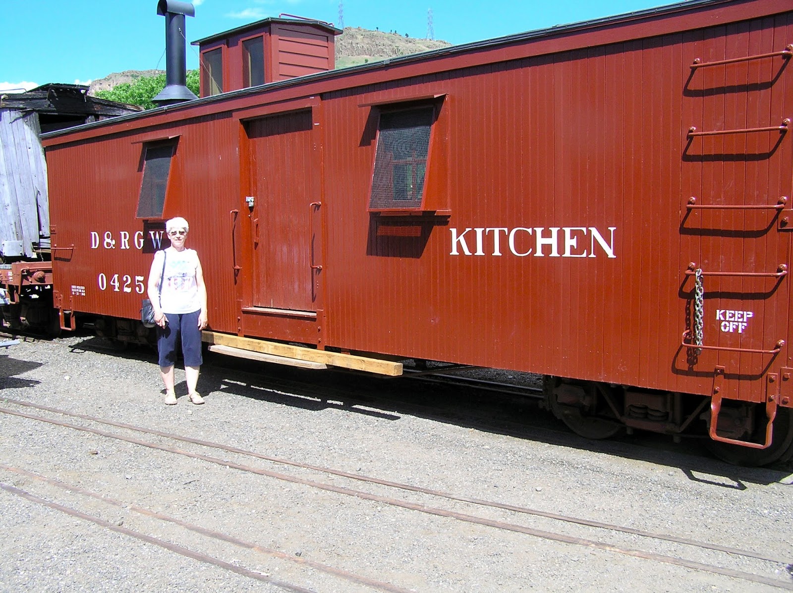
No. 4 is on display in Manitou and another
engine is on display in Denver at
the Colorado Railroad Museum.

Sunday we head back up I-25 to Estes Park near the Rocky Mountain National Park after attending a service provided at the KOA by a local Baptist church. See you later.

Friday, June 14, 2013

Western Swing 2013 - 22 &23 - What was missed, what wasn’t; a parting game

This post is going to cover two days, Thursday and Friday. The reason is that not much happened either day. It also provides an opportunity to give a glimpse of what we missed by not going on the Royal Gorge train and what we didn’t miss. Sound fair enough?

Thursday the Royal Gorge Fire was 40% contained and settling down. That means that nearly half of the fire line was being held though still some work was to be done to stop the spread beyond the evacuation area. Still, there were enough hot spots, smoldering, and damage to prevent the train from safely operating.

Here’s what we missed by missing the trip. In the event you don’t know, the train winds it’s way through the narrow the canyon before entering a narrow gorge only 90 feet in width -- very little room for roadbed, right-of-way, and river.

This is an aerial view of the train winding through a
portion of the canyon. The railbed was originally
laid by the Denver & Rio Grande and is now
a part of the Union Pacific. This is not
as slim as the canyon gets.

A different perspective -- the Bridge, which spans more than 800 feet
from tower to tower, is approximately 960 feet above
the Arkansas River. The trackbed is varies from
10 to 40 feet above the river.

Royal Gorge Park is now owned by the Cañon City and is run by
an amusement company, Royal Gorge Bridge and Park Company.
How is that for a surprise. The aerial tram is one of the popular
attractions at the Park. However, it is no longer functioning
since the suspension cable was destroyed by the
Royal Gorge Fire.

Here’s what we didn’t miss -- seeing the damage done by the wildfire. After further investigation it was determined that the fire started away from the canyon but spread northward with burning embers jumping across the chasm. In all, 48 of 52 buildings owned by the Royal Gorge company was destroyed and US 50 was closed for three days. 40 full-time personnel for the company will be engaged in clean-up operations while 140 temporary workers have lost their jobs. The surrounding area suffered only fire damage with approximately 250 citizens being evacuated and many animals moved to other areas for care and protection. No building owned by individuals were lost though nearly 4000 acres were consumed by the blaze.
Though mainly a pedestrian bridge, the Bridge is 18 feet wide and
capable of carrying vehicular traffic. Note the buildings in
front of the bridge and to the right in the photo.

The buildings, as they appeared two days ago. The photo is from a
Denver newspaper. Smoke is still rising from the fire that
was active at the time the photo was taken.

A converted DC-10 dumps fire retardant on a portion of the
Royal Gorge Fire. The retardant is sprayed over areas
that are ahead of the direction of travel of the fire. The red
dye helps personnel on the ground or in the air
know where the material was sprayed.

Today, nearly all of the residents that were evacuated were allowed to return to their homes under condition that they may need to be evacuated again.

Thursday evening we had our final night at the RV resort as the Freightliner Western Operations Rally came to a close. The meal was potluck with a great variety of dishes available and too much too eat. Following the meal the door prizes were given out in the form of a game. Each couple had a number. As the number was read in a poem, a member of the family would go forward to select a wrapped gift and exchange with another couple based on the instructions of the poem. A portion of the poem is provided below. We have to admit that it was an enjoyable way to involve everyone.

Lucky you, you’re # 1
You get to start all the fun.
So grab a gift and grab it quick.
Cause you're the one who gets first pick.

Number 2 you’re on the way.
It’s time for you to have your say.
Get your gift and when you’re done,
Swap it off with number 1.

Number 3 its plain to see.
It’s your turn to pick which gift ’twill be.
And when your choosing job is through,
Swap with 1 and then with 2.

Number 4 must use your head.
So grab a gift that has some red.
If it doesn’t suit you to a “T”,
You may swap with 2 or 3.

Jump to it, 5, don’t drag your feet.
Take your gift back to your seat.
Wonder of wonders, it’s yours for a spell.
But what comes next, you can never tell.

On Friday morning we left the RV resort in the wooded foothills of the Rockies south and west of Colorado Springs and drove to a different campground on the arid and flat ground south of Colorado Springs in Fountain. What, no trees for shade? Exactly. However, it was cloudy today and did manage to rain a bit at one time this afternoon. Because of the fire northeast of The Springs, the campground was fuller than normal with residents who had trailers and had to evacuate.

We did our normal Friday thing of going to a restaurant for a late lunch. After that Martha returned to her job while Byron went for a hair cut and a shopping trip to Camping World. While returning from Camping World he saw something run across the road. As he got closer he figured out what it was he saw because of the experience of last summer, prairie dogs. Sure enough, on the other side of the highway was a prairie dog village with about a dozen mounds.

The cloudy weather, cooler temperatures, and small amounts of rain helped those engaged in fighting the Black Forest Fire. Thus far it has destroyed over 400 homes, took two lives of residents who were attempting to leave with a few belongs (the garaged door was up and the car doors open). Nearly 15,000 acres have been burned across an area twice that size. Some people were allowed to return to their homes. In all nearly 38,000 were displaced for at least 48 hours.

Our observation is this. A tornado and hurricane may flatten a home and through or soak belongs that can be found or dried. However, a wildfire totally burns everything. Unlike a tornado, there is sufficient warning for a bulk of the citizens much the same as for a hurricane. A fire, however, means being away from home for a longer period.

Unlike last year’s Waldo Canyon fire that was nearly as big, law enforcement and National Guard troops were prepared to halt unofficial access to the evacuated areas with looting not being the problem it was last year.

Tomorrow, we’ll go up Pikes Peak on the Manitou & Pikes Peak Cog Railway. We’re looking forward to the experience. Don’t worry, we’ll have our jackets with us as we walk around for 40 minutes or so at the 14,114-foot elevation.

Thursday, June 13, 2013

Western Swing 2013 - 21 - Mountaindale Resort

Wednesday already? Oh, how time flies when you’re having fun. It also goes by if you’re not.

When we turned in last night the last report on the Royal Gorge Fire was that it had consumed in excess of 300 acres. This morning by 9:30 AM it had consumed over 3,000 acres. US 50 around Cañon, CO is still closed in both directions. By 11 AM the announcement was that it was 20% contained though another fire had broken out near Fort Collins and was heading northward. Jeepers, we were planning to drive past Fort Collins on our way to Gillettee, WY.

Well, how about talking about something different? How about food?

Since our trip through Royal Gorge on the train was cancelled, the schedule for the FCOC rally was changed. This morning we had Breakfast in a Bag. Neither one of us had heard of it so it was an experience. Basically, eggs are cracked and beaten then placed in a freezer bag. Then, the ingredients you want, are added. That included onion, tomato, mushroom, green pepper. bacon bits, and pre-cooked sausage. The bag is placed in boiling water for about 12 minutes (turkey roasters were used). It turned out to be pretty good.

Breakfast in a Bag -- a better name might be boiled omelette.

Later in the day, Byron went to the grocery on the extreme south side of Colorado Springs. The purpose of the trip was to get ingredients for Thursday’s potluck meal. Approaching the city limits the road makes a curve while going down a large hill. At that point he saw the billowing smoke from the Black Forest Fire which is north of Colorado Springs east of the Air Force Academy.

Difficult to see in the photo is the billows of smoke 12 miles in the
distance on the horizon. The great plumes of smoke extend from
the left of the photo to the right. Since 2 PM on Tuesday the
fire spread toward the east and then turned toward the north
before turning back on itself and burning homes and trees
that were’t burned in the first 12 hours.

This is the view from Colorado Springs looking toward the northeast.
The photo was taken Tuesday afternoon two hours after the fire
broke out. The white smoke results from trees and grasses burning.
The dark smoke is from asphalt roofs and other home
construction materials. Thus far, nearly 100 homes
have been destroyed and the fire has yet to be contained.
Dense smoke from the fire has drifted as far north as
Castle Rock and southern Denver.

As he returned from the grocery he could see the smoke from the Royal Gorge Fire in the distance. As of Wednesday night, the Royal Gorge Fire was 50% contained. Twenty building within the Park were destroyed as was the cable over the Gorge on which the cable car runs. Twelve wooden planks on the foot bridge across the Gorge were also damaged.

Byron took this photo before returning to the motorhome. It shows how large the mountains are immediately behind the RV resort as well as the many trees in which the resort is nestled. One mile from the resort on the south side of the road is a two-mile stretch of road where a fire had occurred four years ago.

Can you spot our motorhome? It is just to the rift of the utility pole in the center of the photo. The ground is rocky. Large boulders help terrace the spacious sites.

Last night we learned a new game called “Up Yours”. It is played with ten cards (2 through 6 and 8 through Queen) and two dice. Oh, it also involves 10 nickels to play. The nickels are contributed to the pot when a seven is rolled. The person left with one nickel wins the pot.

That was last night. Tonight the stakes were raised to six quarters. The game that was played was LCR, which stands for left, center, and right. Less risky people play with chips. The three dice have single dots on three sides and the initials on three. Depending on what is rolled, you may give a quarter to a partner to the left or right, or to the pot in the middle of the table. The last player with one quarter wins the pot. We decided that this game would suit us better if dimes were used.

At this point we are wondering what route to take to get to Gillette. If the Black Forest Fire continues and the smoke levels continue to build, Interstate 25 may be closed. If the Big Meadows Fire in Rocky Mountain National Park stays under control (near Fort Collins) then it will presents no danger. At present, our plans to visit Pikes Peak are in a state of flux.


Wednesday, June 12, 2013

Western Swing 2013 - 20 - Denver to The Springs

It’s Tuesday and time to head to The Springs. That’s what the locals call Colorado Springs.

The drive from Denver down I-25 was on another windy day. This time we were going southward and the wind was from the west; the passenger side of the coach. Since it wasn’t as bad as the other times of driving, it seemed somewhat uneventful.

Leaving Denver we thought we’d never get away from houses, offices, and malls. Just south of Castle Rock it all came to an end. Suddenly we were in open country where services weren’t at every exit. It’s also obvious how Castle Rock got it’s name. East of the Interstate it is easy to see Castle Rock Butte sticking out in the open. It’s interesting that a frame of a star is placed on the top and lit during the Christmas season. Some things can’t be erased when they’re accepted by the local culture.


Castle Rock Butte near Castle Rock, Colorado. The star
frame is permanent and lit during Christmas.

There was a big difference between the Denver area and what was south of Castle Rock; it was obviously drier. The trees were green but the grasses were mainly brown. Anna Kyle told us that Denver was abnormally green from the April snows. However, it is still the beginning of fire season in both area. Denver will be about two weeks behind southern Colorado.

Though the address of the RV resort is Colorado Springs, we are at the edge of the Beaver Creek State Wildlife Area about 15 miles south-southwest of the city. The name of the resort is Mountaindale Cabins and RV Resort. We can honestly say it seems like we’re on the “other side of the tracks” from the campground we came from in Wheat Ridge. There are large, rock-covered sites spread among the tall Lodgepole pines. It is nice to have the shade because it drops the temperature a good 10 or 12 degrees from the temperature in The Springs. In fact, it hit 94 there at one point today and it felt like 80 or so on the resort property.

The rock-covered sites are terraced. We have room for the Airstream,
picnic table, and plenty of space to park the Honda Accord.
At times we have some sun but, in general, we have shade
from the tall pines. Of course, there’s enough wind that
we can’t put the awning out; but who needs it? We have
a natural awning.

Shortly after arriving and connecting to cable (no over-the-air TV out her or AT&T or Verizon cellular service, either) we learned of two wildfires that had begun. One was north of Colorado Springs souths and west of the Air Force Academy and the other started on the south side of the Arkansas River in Royal Gorge. By 5:00 pm we could see the smoke starting to build in the sky.

The dark coloring in the clouds is the haze and smoke from the
Royal Gorge wildfire.

Since there was nothing we could do to help the situation, we went on for the first meal of the rally for the Freightliner Custom Chassis Owners Club; our Airstream is built on a Freightliner chassis. We enjoyed meeting new people and having some delicious hamburgers cooked on an open grill. There were originally 21 coaches registered (that’s how we count registrations, by coaches and not people). but three cancelled because of last-minute health reason. That means about 36 people in attendance.

As we were eating dinner the couple next to us, who were originally from Texas and moved to Colorado Springs last year, were concerned about the wildfire near The Springs. Last year their home was burned in the Waldo Canyon Fire. The current fire was about two miles from their home so they returned to check on things.

After the meal the campers divided into four groups to play a game with cards and dice called “Up Yours”. That one was new to us. But, Martha was willing to jump in and learn. All it took was 10 nickels to get in. Well, she didn’t have ten so she borrowed the amount from the rally host got started. As luck would have it, she won the first pot, paid the rally host, and kept playing. Then, she won the second pot. Her luck didn’t hold out, however, though she did come back to the motorhome with three more nickels than she had when she left. If you have none and wind up with three, what is the yield on the investment?

Martha is smiling because she was winning when this 
photo was taken. Her luck didn’t hold out, however.

After starting, the Royal Gorge Fire grew to more than 300 acres. The fire started on the south side of the river and spotted to the north side. The fire was actively burning on Bureau of Land Management, state and private lands though not many houses were at risk. Mandatory evacuations were in effect for an area north of the Royal Gorge. U.S. Highway 50 and the Royal Gorge Bridge were closed in both directions. The Arkansas River was closed for rafters. The Royal Gorge Park was evacuated. Red Cross opened an Evacuation Shelter and an animal and livestock shelter was set up between Canon City and Florence. It is certainly an interesting time to be here thought the closest fire is currently 25 miles from us.

When we walked back to the motorhome the wind direction had changed and the smoke drifting further south. The prediction is that the winds will change direction overnight. Tomorrow morning we find out if the train ride through Royal Gorge has been cancelled because of the fire.

Monday, June 10, 2013

Western Swing 2013 - 19 - Railway Museum and Work Day

Realizing we were within eight miles of the Colorado Railway Museum, we decided to go take a look. Byron checked their website for information, etc. before we left. He also picked up a brochure in the office of the RV campground. Was it worth the time and effort? The answer is: It depends. It depends on the level of railway enthusiasm possessed by the visitor. Except for the displays of memorabilia, all of the engines and rolling stock are outside in the elements. Some are in good shape and others have suffered from the Colorado sun and the more brutal winters.

The main building, which houses the museum, is on two floors. Artifacts are displayed nicely and cover a variety of road names, unlike the Union Pacific depot in Cheyenne. The favorite road name is Denver & Rio Grande, however, of which there is also Southern and Western naming appended to the DRG. There is also a library and roundhouse on the property.

The DRG was a narrow gauge line that wove it’s way around and through the mountains of Colorado. Later it switched over to standard gauge as construction techniques on right-of-way improved and integration with other systems made “going standard” a bit of a necessity. Many of the engines, cars, and cabooses on the grounds are of narrow gauge design. As a result, the wheels, trucks, cars, etc. were all smaller in scale compared to standard gauge cars. Even the cattle cars seemed to be made for shorter animals.

We walked around the grounds where both standard and narrow gauge equipment is displayed. Near the roundhouse the tracks can accommodate both widths of track. Below are a few photos of what can be seen. Though much of the equipment is weathered, it is possible to see a great variety of equipment. A true rail buff would think he had found “the mother load” because there are engines and cars of all types including bobber, drover, and more typical cabooses.


Engine #40 is a standard gauge locomotive built by the Baldwin
Locomotive Works in Philadelphia.

A “bobber” caboose; notice the frame is attached to
four wheels instead of two trucks with bogies with four wheels
per truck. These often rode roughly but served their purpose on
shorter, narrow gauge trains.

This restored Kitchen car is interesting in size.
note how closely to the ground it sits and how
Martha, who is 5' 3", is almost as tall as the
side walls of the work car. This is typical of
narrow gauge equipment; reduced in scale.

This CB&Q business car has received some TLC. From current brochures,
the interior of this car looks as classy now as when it was built
nearly 100 years ago. The museum’s volunteers do restorations
in the roundhouse which was added a dozen years ago.

A complete consist (train and engine) sits on a siding making an excellent
subject for photographs. The engine has been restore and can be used
for excursions and “steam up” days.

Though there is a greater amount of steam locomotives, there are
also vintage diesel engines on display such as this pair of 
Rio Grand F9 A & B units. The engines once pulled the Zephyr passenger
train between Denver and Salt Lake City. The Rio Grande Zephyr 
was the last non-Amtrak, intercity passenger
train in the United States. These units were refurbished and
repainted around twelve years ago.

A sad fact of railway museums is that there are too many of them for the amount of funding required for restoration and maintenance. As a result, most of them have a lot of equipment rusting or rotting one day at a time. There seems to be no shortage of volunteers, however. The saving grace of this museum is that it does have several steam engines in working condition and enough passenger cars to make weekly and special occasion trips a viable source of some funding. 

The museum also has an extensive HO model railroad in the basement offering a great overview of railroad operations in the Rockies. Though not running when we were present, they also have a nice G-guage (garden) layout under shade.

The Denver Garden Railway Society’s G-gauge exhibit at
the Colorado Railroad Museum.

Since this was Monday, Martha had work to do as did Byron. Martha’s pays. Byron’s doesn’t. We returned before noon and went about our separate tasks. Martha transcribed doctor’s reports while Byron updated the website of the GMC Great Lakers.

Tomorrow we head to Colorado Springs. Or, as the locals call it, The Springs.

Western Swing 2013 - 18 - Golden and Red Rocks

Sunday morning at the edge of the Rockies -- the weather was clear with afternoon temperatures near 85. As we learned, the Denver area seems to have only summer and winter with brief periods of spring and fall. The last snow here was late in April. Now summer weather is beginning. We also understand that things are greener than normal because of the late snows.

We attended Crossroads Church of Denver which is also in Wheat Ridge. It began as a home Bible study group in 1976. It now claims 5,000 members on a campus of three, separate buildings. It has also birthed the beginning of a few other churches in the area. We attended the 9 AM service.

The pastor had a very good sermon for the morning based on the theme of living an authentic Christian life. Of course, they follow the “praise and worship” format which means stand to listen to the rock band perform up front while the lights are twirling. It was a bit toward heavy metal at one point because a soloist took off on a wild break implementing stylistic trends of the genré.

Byron, of course, made the observation that less than 1 in 10 actually tried to sing along on 80% of the numbers. There were to portions that were familiar and nearly half of the congregation, which was generationally balanced, singing along. It isn’t our preferred style of worship, which is now called “traditional”, where more of the people actually participate in singing and standing for 25 minutes isn’t the norm. “Different strokes for different folks” and God accepts it all when it comes from the heart. 

Oddly, there was no recognition of visitors. We know there were some present in addition to us because we spotted a couple getting into an SUV with Tennessee plates (Knox County). Another odd thing was the smell of bacon when we left the sanctuary. In addition to serving coffee in the lobby, they also offer cooked-to-order breakfast at the snack bar. Goodness, how convenient does it have to become to get folks up on Sunday morning. How times have changed.

We went back to the motorhome to change and get ready for the afternoon. We were overdressed in our long pants and nice tops though some, at the service, looked prepared for sun bathing under the cloudless sky.

Anna Kyle, Martha’s niece, has been in the area for two years and was to go with us to lunch. After lunch she was to show us some of the area. Wow, we weren’t expecting such a great time. She had a grand itinerary in mind. We weren’t disappointed.

We headed to Golden, which was seven miles on west of Wheat Ridge in the foothills of the Rocky Mountains, we were in search of food. We found a great grill on the main drag through downtown, Washington Avenue. After lunch we walked to Clear Creek. The creek flows from a lake higher in the Rockies and, of course, has rocks and rapids. The city has concrete paths along both sides of the creek with several bridges for crossing. Along the walkways there are several bronze statues of animals and people. Willow bushes lined the creek. There were several people riding mountain bikes as well as many enjoying books with the rapids providing a sound backdrop.


Welcome to downtown Golden - Byron and Anna Kyle pause
for a photograph next to a statue of a bison.

Several kayakers were working the rapids in
Clear Creek. After a group would come
down the creek they would paddle back
and take turns traversing laterally
across the small falls visible above
the red kayak.

The city has done an excellent job in creating the park system on the northern side of the creek. On the south side there was a small, historical village set up to show how the type of structures when Golden was first founded 130 years ago. It is called the Golden History Park.


The silhouettes painted on the wall of a building give you a sense
of returning to the days of the “old west”. The cellular antennae
atop the building are a reminder that this is the 21st century.

There were several people out and about on Sunday. How many were tourists or visitors we have no idea. We just know that most parking spaces were taken and several people were on the sidewalks. However, it is quite different than a nice day in Gatlinburg, TN. One can actually enjoy walking around Golden.


On several street corners there are bronze statues just as there
are statues on either side of Clear Creek. Here, a prospector is 
affectionately hugging his donkey while admiring
a large nugget of gold.

From the downtown area we headed, by car, up the winding road to Lookout Mountain. Yes, there is more than one Lookout Mountain in the US. The difference is that the Colorado version is much broader at the base though similar in height above the city at it’s base. The Tennessee version is at 1,850 feet above sea level; Chattanooga is at an elevation of 675 feet. The Colorado version is at 6,890 feet above sea level; Golden is at an elevation of 5,675 feet. There are also two other differences. The air is much clearer in Colorado with the sky seeming to be a different color of blue. Also, there are yet more mountains above Lookout Mountain in Colorado.

OK. One more comparison. There are more switchbacks in the road ascending to the top of the mountain. Turns are sharp and should be taken at 15 mph. Bikers ride the highway as well in spite of the climb and the work to be expended in pedaling.

Atop a park area near the grave of Bill Cody, the view to other mountain
peaks is amazing. The trees to the left are in elevations below 8,000 feet.
In the distance the hills are higher yet with fewer trees. Still yet, on the horizon,
snow-capped mountains can be seen. No, they are not white clouds because
the sky was absolutely clear on Sunday afternoon.

From Lookout Mountain we headed back to Golden for ice cream and a drink of cold water. After being refreshed, we drove to Red Rocks, the well-known amphitheater. When we arrived we found that the it would soon be closing in preparation for a concert by Celtic Woman.

What is amazing about this place is that photographs do not do the open-air space justice. There is a large, tilted, disc-shaped rock behind the stage, a huge vertical rock angled outwards from stage right, several large outcrops angled outwards from stage left and a seating area for up to nearly 10,000 people in between. The acoustical properties, of course, are perfect for a concert venue. The first performance of each season is the Easter Sunrise Service, a non-denominational service on Easter Sunday of each year.

This formation at Red Rocks is called “Creation” and is on the southern
edge of the amphitheater. A formation very similar rises on
the north end. It is called “Ship Rock”.

On either side of the covered stage at Red Rocks are two structures that house
the speakers for the sound system. The saucer-shaped rock formation
to the rear helps project the sound into the seating area.

Performers report that the view of the mountains from the stage is just as awesome as the view the audience has of the valley and hills behind the state. The buildings of Denver can be seen on the horizon to the left of the photo. To support the many cars that bring people to this point, there are three, large parking areas dug out from the hillsides. However, the parking areas are not on the same level as the amphitheater. Yes, it is a climb. Fortunately, there is a handicap area behind the theater that can accommodate several vehicles. One would need to plan extra time for climbing in order to get to a seat before the start of a performance.

After driving back to our space at The Prospect, we took the dogs for a walk along the shore of the large lake at the park next to the campground. A few people were fishing while many Canada geese swam on the lake. It was a great way to “call it a day”.