Monday, September 18, 2023

Day Twelve - 9/16 - Spokane, Washington

Pavillion
The tall structure in the center was originally covered with canvas
and served as the US Pavilion for Expo ’74. Since then it has
remained and served many functions for Spokane.

Today was not a travel day but a sightseeing day. We returned to the Spokane Riverfront Park to pick up where we had left off the previous day. We still had some things to see and do.

We parked in the same lot as yesterday and walked across the former vehicle bridge that is now for pedestrians only. In the middle of the park area are two islands. The islands stretch from the upper part of Spokane Falls to the lower part.

One island was formerly called Canada Island. It was renamed in 2017 and now has the Salish name that translates as Salmon People (sn̓x méne pronounced “sin-HOO-men-huh”). It is a relatively small island and sits almost at the head of the upper falls.

The other island is Havermale Island. It served as a refuge for the citizens of Spokane during the battle with the Nez Perce Indians in 1877 and offered refuge to the citizens once again during the Great Fire of 1889. By the beginning of the 20th century, Havermale was developed as an industrial area. It was on this island that the Great Northern Railroad built their depot for Spokane (eastern part of the island) and Washington Water Power Company built their power generating station (western section).

As Spokane continued to grow, the island, due to size, became less attractive to industries and many moved from the island. By the 1950s, the rail yards on Haverhale and the southern banks of the Spokane River were slowly being vacated. An impetus to renovate the island came in the early 1970’s as the city prepared to host the Expo. Only the Pavilion, the Gondolas, and the Clock Tower remain from Expo. The Looff Carrousel was relocated to the park in 1975 from Natatorium Park, a historic amusement park that closed in the 1960s.


It was a bright, sunny morning when we returned to Spokane’s
Riverfront Park. This photo begs the question: “When will
Byron learn just to smile and not worry about the camera?”
The Clock Tower from the Great Northern RR Depot
can easily be spotted anywhere in the park.

On our morning visit we circled around to The Childhood Express, a 12-foot-high and 27-foot-long Radio Flyer wagon with a slide for the handle. Martha got a few strange looks from kids on the slide as she climbed the ladder to go down the slide. 

Martha and the Radio Flyer
“That was fun," Martha said with a grin.

From the slide, we made our way to the garbage coat (designed for the World’s Fair (Expo ’74) as an environmental statement. The goat eats small pieces of garbage with the aid of a vacuum that sucks trash into the digestive system. 

Feeding the goat
Feeding the goat. All that is required is some waste paper.

A visit to the Visitor Center was next while waiting for the Looff Caroussel to open at 11 o'clock. Outside the Visitor Center is the Rotary Fountain, completed in 2004 and refurbished in 2016. It serves as an ideal splash pad for children during the summer months.

When the Caroussel opened, we bought tickets so we could both ride. This particular carousel (of which there were three spellings for the word when it was built in 1909) is rather fast compared to others we have ridden. The ride features 54 horses, one giraffe, one tiger, and two Chinese dragon chairs. They were all hand-carved by one individual over nearly two years.

Carousel at Riverfront Park
The Caroussel, which had been at the Natatorium until the
1960s, was dismantled and stored for nearly thirty years.
It was moved to Riverfront Park, refurbished, and placed
in a building that resists UV light while protecting it
from exposure to the elements.

Martha on the horse
The animals of the carousel have been beautifully restored. However, some
of the decor elements were not though the ride’s mechanism was.

We returned to the motorhome for the rest of the afternoon so we could watch what remained of the Georgia football game. The Bulldogs beat the Gamecocks 24 to 14. The Dawgs pulled it out in the second half.


Saturday, September 16, 2023

Day Ten - Clinton (Missoula) to Spokane Valley, WA

Since today was a shorter travel day and we could not check into the Spokane KOA Journey until 2 PM, we did not get on the road until about 10:30 AM Mountain Daylight Time.

An anomaly in our morning occurred when starting the Lincoln MKX to put it in Neutral Tow Mode. The check engine light came on. Of course, the alert could be caused by many things. Not being sure what the light was about, Martha did some reading. It became apparent that the first step was to check the fluid levels. Well, forget that. Engines are so tightly tucked under the hood that access to a dipstick is nearly impossible. This is not the 1960s when it was more simple. We had the oil changed and new rear brakes installed before leaving the Louisville area so decided to just have the transmission fluid changed upon arrival in Spokane.

Since we had crossed the Continental Divide on Thursday and we were still at 3500 feet elevation, we knew we would not be climbing in elevation very much today. We would, however, descend 2000 feet into Cour d’Alene, Idaho, and the Spokane Valley just across the panhandle. I can truly say, I was very grateful for good air brakes and a functioning engine brake on the motor home as we descended the mountain.

For those interested, diesel-fired rigs have air brakes. That means that air pressure is used to keep the service brakes from engaging. It is a safety feature, too. An over-the-road diesel engine also has what is called an engine brake; sometimes called an exhaust brake. The service brakes and the engine brake help in slowing down something the weight of a 22,000 lb. motorhome. We also have proportional braking control in our tow vehicle. As the brakes are engaged in the cab, the brakes are applied in the SUV. Still, braking a large unit isn’t like applying the brakes on an automobile which has less inertia. Speed becomes an enemy when going down a steep grade so having the engine brake slow the RPMs and the service brakes to slow the rotation of the tires all works to accomplish the desired task; that of reaching the bottom of the grade safely. 

After arriving at the KOA we took off for the local Valvoline location and had the transmission fluid changed. We now feel much better about the situation on towing our car "all four down."

After the Valvoline visit, we had time to walk around the Spokane Riverfront for a late afternoon visit. The weather was nice with the temperature just right and the sun shining brightly. After having an early dinner at a restaurant called Kasa Taphouse, we walked around the park area where Expo ’74 had been staged.

1994 Expo Site
This photo was taken near the head of the upper falls. The structure
was erected for the Expo ’74. It housed the US Pavilion.
The clock tower, to the right, is all that remains from the 
original train station since the main depot was during the
renovation of the area in preparation for the world exposition.
As then, the clock is not electrified so it has to be wound by 
a human several times a month, after climbing the steps.

Spokane is a city built around the falls in the Spokane River.
The upper falls area is a lengthy series of rapids among the rocks.

An island separates the north and south sides of the falls. The wider
and more dramatic falls are on the northern side of the river.
This is a view of the lower falls looking upward. The drop
in the cascade is very great across the lower falls.

Martha at Sculpture
The park area at the lower part of the falls (still on the island)
features art and exhibits about the indigenous inhabitants
of Washington and the Northwest.

Sign explaining salmon fishing
The interpretive sign at the base of the lower falls describes the importance of the falls
to the natives that lived in the area for thousands of years.

Day Nine - Billings, MT to Missoula, MT (Clinton)

It was another travel day. Thankfully, we’re not traveling by wagon train. This day is marked by the scenic drive on I-90 along the southern part of Montana from the east to the west before hooking northward. This route includes more criss-crossing of the Yellowstone River (as it flows to the Missouri from out of Yellowstone National Park). Cities include Billings, Livingston, Bozeman, and Butte. Just before Butte, we crossed a continental divide and started following the Clark Fork River toward Missoula and our stopping point for the day.

Montana's rivers
Our travels through Montana have followed either the
Yellowstone or the Clark Fork Rivers. The Clark Fork
was originally called Clark's River. Later, it was determined
to be a fork of the Columbia River.

From Billings, we encountered some beautiful views of the Yellowstone River and the Absaroka Mountain Range. We also crossed the Continental Divide at 6393 feet between Bozeman and Butte, Montana. Our primary purpose for this trip is explore Washington, Oregon, and California. We just have to get there first. Along the way we get to enjoy some beautiful scenery and visit some National Parks.

We stopped at Bearmouth Chalet and RV Park in Clinton, Montana which is southeast of Missoula by 35 miles. This was another 300-mile travel day. It was early afternoon on Thursday.

To date, we have driven approximately 1934 miles. From here on, our travel days will be shorter and further apart as we spend more days stationary so we can explore the different areas. On Friday, we have a 220 mile day to our destination of Spokane, Washington.

Old Motorcycle
Carrying out the theme of a ghost town, this motorcycle seems
to give evidence of such.

The full name of the RV campground is Bearmouth
Chalet RV Park. Too much for the sign. The campground
is along the Clark Fork River.

There's even a hotel at this campground making it
a vacation spot where winter hunting and 
summer fishing can be enjoyed.

Before arriving in Clinton (Missoula area), we had to descend from the Continental Divide in the Bitterroot Range of the Rocky Mountains.

At this point you may be asking why we’re doing this blog. Well, we have a couple of reasons. We both have Facebook accounts and post some things there. Not everyone follows us on Facebook. Besides, Facebook is terrible for going back and looking at previous posts. And that brings up another reason; our minds sometimes forget when or where and this blog catalogs things in such a way that our minds can be jogged into correct recall.

Friday, September 15, 2023

Day Eight - Dickinson, ND to Billings, MT

We departed Dickinson around 9 AM on Wednesday with a 323-mile trip ahead for us — destination, Billings KOA Holiday. We traveled west on I-94 and crossed into Montana about 70 miles west of Dickinson.

Up until now, we have been traveling along beside or somewhere in the vicinity of the Missouri River. Today, we said goodbye to the Missouri and said hello to the Yellowstone River. The Yellowstone River is considered the principal tributary of the upper Missouri and is approximately 692 miles long. We have crossed paths with the Yellowstone River several times on our journeys through Montana and South Dakota.

The Yellowstone River is one of the prettiest rivers as it meanders gracefully through valleys and across plains as it skirts about the Absaroka Range. It has a wide riverbed in the sections we’ve encountered. Also, we have often driven parallel to railroad tracks. This is a new section of highway that we have not traveled before. By the way, we have had some of the best roads in the country across this north-central section of the United States. It hasn’t been at all like we anticipated. It has been better. For sure, the roads have been better than we’ve become accustomed to east of the Mississippi.

The Absaroks Range, by the way, is a sub-range of the Rocky Mountains. The range stretches about 150 across the Montana-Wyoming border. At the widest point the range is about 75 miles. It goes from the eastern boundary of Yellowstone National Park near Paradise Valley and into the western side of the Bighorn Basin. (Yes, that Bighorn where Custer and his troops met up with thousands of angry Lakota Sioux, Northern Cheyenne, and Arapaho tribal members who were tired of being pushed around. Apparently, one thing Custer didn’t learn at West Point was the wisdom of sizing up the foe before going into battle.) We drove past the battleground by did not stop since we had been there before. If you’ve never had the opportunity to do so and are nearby, we recommend doing so.

So far, we have had great traveling weather, with rain only as we departed South Sioux City, Nebraska. As we approached Billings today, we watched a storm move north of us. We encountered a small rain shower but mostly only encountered winds from the storm.

Interstate I-94 intersects with and ends at I-90 about six miles east of Billings. From here our journey will be on I-90 as we travel over a significant distance we have driven before.

We arrived at Billings KOA around 3 PM. Billings KOA Holiday has been a stopping point several times in the past and is one of our favorite KOA campgrounds. In fact, the Yellowstone River flows past it. In caves across the river from the campground are petroglyphs that are a feature of a state park. The Billings KOA is the first KOA in the nation and opened 61 years ago to serve travelers heading to the World’s Fair in Seattle.

Shamelessly, Byron wanted the next photos plucked from the KOA site to show the setting at the campground.

The playground at dusk with barnyard scene.

Miniature (putt-putt) golf.

Some of the cabins are along the Yellowstone River.


Thursday, September 14, 2023

Day Seven - Theodore Roosevelt National Park

We left our motor home at the campground for the day. Using the car as our mode of transportation, we headed back to Theodore Roosevelt National Park. 

TRNP is unusual in that there is not an interior roadway to allow visitors to drive through from one end to another. We decided to head to the North Unit first, about an 90-minute drive from Dickinson. (On the way we observed quite a number of new oil wells actively pumping).

After arriving at the North Unit, we watched the short video about the park before actually heading into the park. The North Unit has a 14-mile road that ends at Oxbow Overlook. We also stopped at River Bend Overlook and took the short walk to the stone shelter built by the Civilian Conservation Corps in the 1930s.

The Visitor Center at the North Unit is, basically, a modular unit.
It isn’t quite up the the standard one would expect of a
national park location. By the way, a park ranger took this photo.

Byron pauses to take a photo of Oxbow Bend of the Little Missouri River.

From the River Bend Overlook one is able to see the bow effect created
by the flow of the river over time. Those who have studied the geological
behavior of this area point out that there are at least two groupings
of Cottonwood trees around the bend. One is much older than
the other and was first formed when the bend was more widely separated
by the land between. As the result of flooding, new seedlings moved in
and grew taking root in a smaller circumference. In years to come,
it is likely that the river will cut across the land mass and
the oxbow gradually go away leaving some trees to mark
the former course of the river.

Martha makes her way down the rocky path to the CCC
structure that was built on an observation point.

It is here that one should stop to admire the contributions of the Roosevelt presidents, Theodore and Franklin. One initiated the setting aside of land for public use while the other initiated programs that resulted in enhancing the parks for exploration by visitors by building trails and structures. Both were considered progressive for their times though one served as a Republican and the other as a Democrat. And, yes, they were closely related through family ties and states of residence.

After a picnic lunch at Oxbow, we headed back toward the North Unit entrance/exit and stopped for a 1.8 mile hike before exiting the park. At times we were following following a bison who was also making his way through the park. Interestingly, the bison will climb more steeply up some hills than we humans choose to do. We walked through both areas shaded by trees and bushes while other parts of the trail were fully open to the sun.

On the trail through the wilderness — that’s Martha
and not John the Baptist.

We arrived at the South Unit in Medora about mid-afternoon and viewed the exhibit in the Visitor Center there. At the back of the building is the Maltese Cross Cabin in which Roosevelt once lived.

The South Unit area of the park is less dramatic as far as the geological makeup is concerned. It does, however, support more wildlife including the prairie dog towns. Though they are difficult to see, the prairie dogs offer some interesting entertainment. 

We drove back as fas as the Wind Canyon Trail for a short hike. This canyon is interesting. Most of the other portions of the park have been shaped by water erosion. This canyon has been and is being shaped by the wind.

A narrow canyon opens to the wide buy shallow Little Missouri.

The Sioux called this area mako shake which means “not good land.” The frontier soldiers that traveled through this area called it “hell with the fire put out.” Roosevelt said it was “land of vast silence – a place of grim beauty.”

As you well know, pictures don’t do justice to the majesty of the land and views to be seen. Though the North Dakota Badlands aren't as colorful as the South Dakota Badlands, they are still fascinating yet more compact. If you travel this way and stop at the Painted Canyon rest area, you'll miss the close-up experience to be had by traveling through both sections of this park.

Wednesday, September 13, 2023

Day Six - Aberdeen, SD to Dickerson, SD

Another travel day. This involves getting up in time to hit the road at 9 AM if possible. We have miles to go before we sleep. The only promises to keep are those of seeing places and doing things that remain on the bucket list.

We left Aberdeen, South Dakota with a 300-mile trip ahead of us. We headed northward on State Highway 281 toward North Dakota. This would be our first time to be in that state. The further north we travel, the less populated the area becomes. Highway 281 is a two-lane road. Other than two small towns with speed limits of 35, we were able to travel at our normal speed of about 62 mph.

Corn and soybean fields were our traveling companions again today. Like some much of the wide-open prairie of the Great Plains, one can drive for miles without seeing a house. Then we see someone’s farm or ranch and grain silos way off the road, surrounded by fields of crops or cattle. Then, just as quickly one sees them, they fade into the passing horizon before seeing another, similar setting.

Martha wrote the following in a Facebook post. “I am by no means an extrovert. I enjoy my solitude and quiet, but I’m not sure I could survive here. I do enjoy face-to-face interaction with people daily.” Byron also enjoys watching people too much to enjoy being alone on the prairie.

We intersected with I-94 at Jamestown, North Dakota and turned west toward Dickinson, North Dakota. As we traveled I-94, we traded fields of soybeans for acres and acres of sunflowers interspersed with fields of corn and wheat, all in various stages awaiting a sure harvest sometime later this fall.

We crossed into the Mountain Time Zone about 30 miles east of Dickinson. We arrived at North Park Campground a few minutes after 1 PM and still had a good amount of daylight left. So, we headed out for the Painted Canyon Visitor Center at Theodore Roosevelt National Park. This was to be our first glimpse of the Park. We’ll return to see the North and South Units of the Park and also visit the small town of Medora.

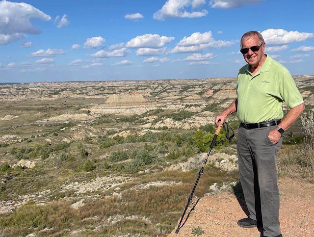
Martha and Byron at Roosevelt National Park
Yes, here we are at TRNP that was established in 1947 as
a tribute to President Roosevelt.

Interpretive Sign at TRNP
An interpretive sign that tells a bit about about the wind
and water erosion that makes up a part of this region
of the North Dakota Badlands.

Byron on the Edge
As Byron mentioned in a Facebook post, 2D photography is deceptive.
His walking stick is on the edge of a drop-off. Two inches
to the left it is a significant descent to the land below. 
Behind are the erosive buttes, etc. that vary in size
but are probably 250 - 400 feet in height.


Day Five - Sioux City to Aberdeen

Today was another travel day. We left Sioux City in a much needed rain for the area. We continued north on I-29 to Summit, South Dakota where we headed westerly on Highway 12. We enjoyed a pretty drive through the Blue Dog Lake area before arriving in Aberdeen around 2:20 pm.

While traveling along Highway 12, there were road signs mentioning The Yellowstone Trail. The Yellowstone Trail was established in 1912 and was the first, transcontinental highway through the upper tier of the United States. The trail ran through Aberdeen. Today, of course, it is nicely paved.

Though the highway on 12 to Aberdeen was two-lane much of the way, it was also good pavement with little traffic. This stretch of our route was across the gently rolling prairie of the Great Plains. Since this was a Sunday, Martha played some music from one of her favorite Gospel performers, Linda Randle. Later on in the day we listened to some Broadway hits of the 50’s, 60’s and 70’s. We’re accustomed to switching drivers every two hours or so. Today it was no different.

Though the road may seem flat, it can be rising in altitude very
gently without even noticing. The weather was ideal upon
leaving since we started at around 60° and arrived with
the high being around 72° F, which was ideal.
 
This was the first day of our journey that we didn’t need the roof air conditioner powered by our 7,000-watt generator. It provided a good opportunity to see how the new residential refrigerator/freezer performed on the inverter. It functioned well keeping the refrigerated section at 40° and the freezer at 0°. Previously, we had an RV refrigerator/freezer that would, at times, struggle to keep the food properly cooled and the freezer doing the same. Now that we have the new Hotpoint, we have an all-electric kitchen. Gone is the reliance on propane for the cooktop and refrigerator. For us, this is quite a nice feeling.

Another common sight in this part of the USA is that of baled
hay along the wide right-of-way.

Do we know the way to San Jose? Absolutely. 

Several months ago Byron installed a new radio in the dash that has a 9-inch screen. It is CarPlay compatible. It is nice that it is within easy view while driving. On this trip we’re giving RV TripWizard a try since the app works with CarPlay. Apple’s Maps isn’t designed for RVers since it isn’t aware of any height or weight restrictions. Maps doesn’t allow you to adjust other settings, either. For instance, Maps assume that a car (and auto speeds) is being used with the GPS. RV systems do.

On the dash (to the right) you’ll see Byron’s iPad which is running CoPilot, the trip routing software we’ve used since 2016. It is not compatible with CarPlay. Therefore, we’re able to see the differences in the display of information as well as the differences the software chooses in providing suitable routes. Though they are similar, they yield different results at time, especially when approaching exit ramps or turns where there are multiple lanes involved. CoPilot is much more precise.

At Aberdeen we were in for a nice surprise. The campground was a part
of the city park system. It is in one corner of the 252-acre facility which
also has a theme park in addition to the normal things one would expect.

Byron is standing in front of the campground office and lodge.

Campground Map: Wylie Park at Storybook Land. For sure, we weren’t 
expecting such a nice place with such a variety of amenities. They even
have a mid-gauge steam train that runs on a one-mile
loop of track.