Today was another travel day but it was quite different from the others. First, we didn’t have as far to go and, second, it was more of an “adventure” because of what were discoveries for us along the way.
Thus far we have traveled 1,830 miles since leaving our home in Louisville.
The Flagstaff KOA, our departure point, is nestled among pine trees and mountains. After about five miles of travel we entered Navajo territory which is flat, desert land with majestic, treeless, canyon walls on every side. We traveled across Navajo lands for about 140 miles.
Honestly, we weren’t quite sure what to expect other than some twisting roadway which shows up on Google Maps. Martha was not sure if she would like the ride for this day. Though she loves the mountains she does not like riding in them; especially when the cliff is on her side of the road. Since we knew we had to go up (Flagstaff is at 6000 feet), we never dreamed we would go down first. The ride proved to be delightful but humbling.
As you look out across the dry, dusty landscape you see lone houses sitting in the hot sun — there is no grass, no trees, and looking very small against the backdrop of such large mountains cliff and bluffs. Many of these inhabitants still have to have their water brought in because a source of water isn’t to be seen anywhere, even in the small Navajo communities. Along the way there would be small clusters of houses (the communities), but most of the houses stood alone. Another surprise is that every five or six miles there is a small hut where the inhabitants sell their handmade wares. Nearly every one was flying a US flag, Arizona flag, and a tribal flag. Once in a while you would see some cattle standing under a tree for shade. The trees were sparse but the cattle knew where they were. Again, the surprising thing was we were going down.

Traveling north from Flagstaff, the highway goes through Navajo territory with cliffs on either side of the road that stretch for miles and miles.
A little past midway to Kaibab we crossed the lowest point, the Colorado River which winds through Marble Canyon before flowing through Grand Canyon. What a site to behold and how surprising to discover! The river was very still it seemed, but after looking closely you could see ripples of movement across the top of the emerald green water. There was a lodge, restaurant, and a nice Navajo Interpretation Center run by the National Park Service. This point the main crossing point across the Colorado for hundreds of miles in either direction.
Actually, we crossed the Colorado on a bridge 400 feet above the river's surface. Below us was Lee Ferry which was the original method of crossing the Colorado until 1929. In that year a bridge was built joining the cliffs on either side of the Colorado, a span of nearly 900 feet across Marble Canyon. A new bridge was built in 1995 and the old bridge was turned into a pedestrian and equestrian bridge. By agreement with several agencies, the new bridge was designed to look like the old one. Below us, on both sides of the bridge, we caught a glimpse of kayaks tied to the banks with their passengers on the riverbank. Obviously, this is one method of floating down the calm part of the river.

The 1929 old bridge is on the left. The 1995 bridge is on the right. These span Marble Canyon 400 feet above the Colorado north of The Grand Canyon.
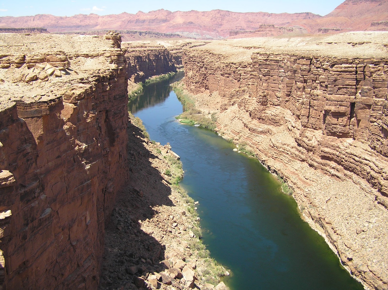
The quiet Colorado as it flows southward. Not obvious in this photo, a float group was tied where the little bend is in the river where there was a sandy beach and some shade.
At this point on our trip we were at an elevation of 3600 feet. Leaving there we continued across the canyon traveling in a southwesterly direction. Not until the last two dozen miles, near Jacob Lake, did we enter Kaibab National Forest and begin our climb on twisting, turning mountain roads. In a matter of minutes we went from dry and dusty canyon travel to land inhabited by tall trees and green plateaus.
We reached our campground around 3:30 p.m. at a height of 7920 feet. There is no need for air conditioning up here. As a matter of fact, it got very cool as night time approached. By morning we were under the comforter and wishing for heat. (We now have the thermostat set to control the heat in the motorhome.)
We’ve been gone from home 10 days and we have learned a few things. One thing is that animals do not adjust to time change like we humans do. A trip into central time zone does not throw them off schedule and we humans can make the adjustment for them. But, we are now three hours behind Eastern Daylight time in Arizona’s Mountain Standard and the animals want to maintain the same time of eating regardless of the time zone. Instead of eating at 7:00 a.m. EDT they want to eat at the first ray of light which, out here, comes at about 4:15 a.m. MST. Martha has tried ignoring them until at least 5:30 a.m. here but last night she decided to join them. Lights were out at dark, around 8:45 p.m., and when the whining started at 4:30 a.m. she and the dogs got up.
Another thing we have learned is that it gets light very early out here. The morning we left Albuquerque, the dogs were up at 5:30 a.m. It was as bright outside as it is at 8:20 a.m. at home. It just shows you that Louisville should return to the Central time zone and forget the craziness of Eastern. It also gets darker earlier in the evening, even on daylight savings time.

Some of the large boulders that are on the roadside. They have fallen from Vermillion Cliffs and are too large to move with typical equipment.

An unusual rock. A search of the Internet revealed several family photos in front of this rock along the highway parallel to Vermillion Cliffs.

Louisville to Oklahoma City by way of the Fairfield, Illinois area.

Oklahoma City to Kaibab Plateau in north of the Grand Canyon.
No comments:
Post a Comment