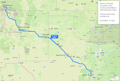
OK, folks. These are our travel days with no stays for visiting the local areas. Just travel. Sounds boring? Not so. Keep in mind that wherever you go throughout the USA, the landscape (topology) can change drastically and often. Each area has it’s own beauty and reason for being as it is.
We left Mancos, Colorado on Sunday, October 22, and headed east toward Durango before turning southeast toward Albuquerque, New Mexico. We crossed the southern Continental Divide about 60 miles north of Albuquerque at 7380 feet elevation. When we crossed a northern Continental Divide in Montana we were a little over 6000 feet. Since that crossing north of Albuquerque, we’ve been on a downhill trajectory. Yes, we’re over the hill in more than one way.
As we turned south in Durango, we encountered a scene that
was quite colorful for the region. The cottonwoods, always
found near water, had changed to their golden, fall color.
Monday’s travel was between Bernalillo, NM and Clovis, NM (October 23) in more of an easterly direction. We were still in somewhat desert-like territory for a portion of the journey.
The formations that “jump up” in the middle of the wide-open
spaces is always amazing.
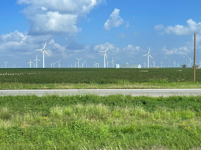
Tuesday, the 24th, when headed toward Sweetwater, Texas which is west of Abilene. We were on flatter ground that we had been for some time. We had also returned to civilization in terms of distances between towns not being so great and farm or ranch houses also being closer together. Farmland? Yes, that was also experienced. Then, before getting into Sweetwater, we started seeing a great number of windmills (alternative energy production) across much of the landscape. In fact, what we were seeing is called the Sweetwater Wind Farm which boasts 392 turbines manufactured by GE Energy, Siemens, and Mitsubishi. They stretch across 144 square miles of West Texas. When built, Sweetwater was the biggest wind farm in Texas, and in the world, when it was built. Below many of the turbines and blades were oil well pumps, 90% of them standing idle.
Much of the Sweetwater Wind Farm is in open farm country
though several are in former oil fields.
Settled in for the evening, we enjoyed being where there was
grass and not just rocks and dust. Click on the photo
to see an enlarged image then look at the price
of gas and diesel fuel — get it while it is “on sale.”
Our last day of travel, Wednesday (10/25), was a little more harrowing than expected. We encountered heavy rain as we left Sweetwater, Texas. We encountered a few accidents upon approaching Abilene that slowed traffic. Then, in bypassing Abilene we had to dodge a wet, wandering dog in the center lane of traffic. Within miles of that scare we had a small sliding experience with a slick road surface caused by the heavy rain. Thankfully, everything was kept under control and we arrived in Leander, Texas with no further incident. In fact, by the time we arrived the dark skies had given way to an overcast condition. We were safe and sound.
We encountered an internet friend of Byron’s at the
Leander / NW Austin KOA. He was a member of a
Facebook group Byron started for work campers in 2017.
Even though we’ve traveled four to five hours every day, it has been nice to have some down time each afternoon and evening. Tomorrow, we head to College Station, Texas to visit the George H. W. Bush Presidential Library and Museum on the campus of Texas A&M University.


No comments:
Post a Comment